


Hike the Homestead Trail at Red Top Mountain State Park, following the ultra-scenic banks of Lake Allatoona to beautiful lake views, and exploring a forest filled with fern and wildlife.
(round trip)
moderate
friendly
LOCATION:on Lake Allatoona, north of Atlanta
PACK:our Osprey day pack and our hiking gear list
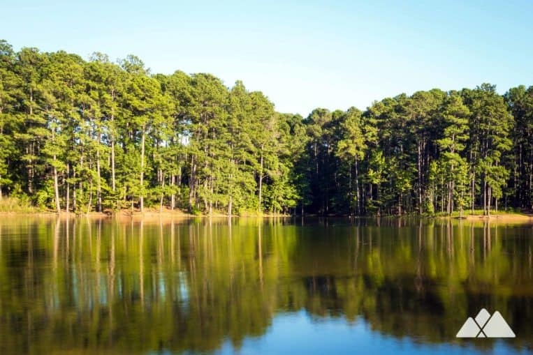
This is one ultra-scenic hike, winding and meandering along the finger-like contours of the Allatoona shoreline. It’s also the longest trail at Red Top Mountain State Park, offering a beautiful mix of stunning lake views and sun-dappled forest along a relatively moderate loop. The Homestead Trail explores quiet, glassy coves, wide-open views of the lake, and a whole lot of beautiful pine and hardwood forest along the way.
From its trailhead, the five-mile Homestead loop hikes a mile north to Lake Allatoona, wandering through a forest filled with ferns, wildflowers, and wildlife. Reaching the lake’s shore, the hike begins a meandering 3.5-mile loop, rolling elevation and catching stunning view after view. And with plenty of shoreline access, it’s one of our favorite dog-friendly hikes in North Georgia, offering many chances for a mid-hike swim in the lake.

Red Top Mountain Homestead Trail: the hike
The adventure begins at the park’s cabin-like visitor center (view maps and driving directions). The hike dives into the forest, following yellow trail blazes under a mixed pine and hardwood forest filled with vibrant green fern.
The trail passes a small, boulder filled creek bed in a mossy, fern-filled valley and then arcs toward a park road. The hike passes through a grove of young, vibrant green pine at .9 mile, continually following the Homestead Trail’s yellow blazes through several trail intersections. The trail begins a gentle climb, hiking through a second grove of young pine before crossing Lodge Road at 1.25 miles. Just after crossing the road, the hike starts the loop portion of the trail, turning right at the intersection, following the loop counter-clockwise.

The trail follows the contours of a meandering stream in a valley filled with large, scattered boulders. Wildflowers thrive trailside during warmer months, abundantly filling the forest floor with color. The trail approaches a large lake inlet at 1.5 miles, beginning to follow the contours of the lake’s finger-like peninsulas.
The shore’s iron-rich soil and rock contrast vibrantly with the cool blue-green tones of the lake. Boulders line the lakeshore, buffering the shore from the wake of passing boats. The trail begins a moderate climb through the coniferous forest along the lake, winding towards the west side of the Red Top Mountain peninsula. The hike ascends to a small knob at 3.8 miles.

Wildflowers and wildlife are a common sight in this remote stretch of trail. Deer, frogs, and reptiles frequent the rolling hills and shallow valleys near the lake’s shore, and the cool, shady forest is a great place to stop for a break and quietly watch for the forest’s creatures.
The trail descends slightly at 4 miles, following Lodge Road towards the completion of the Homestead Loop. The trail turns right at the loop’s end, crossing the road and doubling back on the 1-mile spur trail to the trailhead, retracing its outbound steps. The hike reaches the park’s visitor cabin at just over five miles, completing the adventure.

More adventures at Red Top Mountain State Park
In the area with energy and daylight to burn? Catch wide-swept, elevated panoramas of Lake Allatoona and the Atlanta skyline from the nearby Pine Mountain Trail in Cartersville. Or catch a stunning sunset over Lake Allatoona on the Iron Hill Trail at Red Top Mountain. And check out our Lake Allatoona hiking guide for even more adventures at this beautiful North Georgia lake.

Please Remember
Always leave no trace, pack out everything you pack in, and if you see trash, pick it up and pack it out.
Stay on the marked trail, tell someone where you're going, pack safety and wayfinding essentials, and don't rely on a mobile phone to find your way. Please always practice good trail etiquette. And before you go, always check the trailhead kiosk, official maps, and the park or ranger office for notices of changed routes, trail closures, safety information, and restrictions.
Red Top Mountain Homestead Trail Map, Directions & Details

Love the trail?
This trail is maintained thanks to the hard work of countless volunteers and donations from supporters of the Friends of Georgia State Parks. Please support them by making a donation or joining a volunteer day. Let's work together to keep these fantastic trails maintained and open for use!
Driving Directions
Parking
$5
GPS Coordinates
34.148133, -84.707267 // N34 08.888 W84 42.436
Elevation Profile


