


Follow the ADA accessible Lakeside Trail at Red Top Mountain State Park, exploring an ultra-scenic, paved, kid-friendly path on the Allatoona Lake shore and visiting a historic cabin.
(round trip)
paved
friendly
LOCATION:on Lake Allatoona in North Georgia
PACK:our Osprey day pack and our hiking gear list
It’s not a long trail. And it’s not a challenging one. But the Lakeside Trail at Red Top Mountain State Park is a great walk or jog for families with young children.
From the reflective, glassy waters of a cove on Allatoona Lake, to a trio of historic buildings, the trail packs a lot of beauty and interest in a short distance. And the Lakeside Trail runs nearly level and is paved, too, for easy access and ADA accessibility.


Red Top Mountain Lakeside Trail: the details
The Lakeside Trail departs the park’s office and visitor center (view maps and driving directions), following a paved path on the southern end of the parking area. Approaching the shore of Allatoona Lake, the trail meanders under a canopy of long-needled pine and deciduous trees. The trail catches nearly continual views of a lake inlet, with glassy, calm water reflecting the treeline of the opposite shore.
The Lakeside Trail passes several benches and shaded picnic areas as it contours the Allatoona Lakeshore. The trail arcs westbound at .35 mile to visit the Vaughn cabin, a historic 1800s cabin that was recently moved to the park.
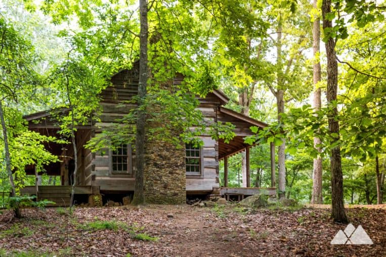
Departing the cabin, the Lakeside Trail loops northward, passing a second, smaller log cabin and approaching the shore of Allatoona Lake once again.
The trail loops to the southwest, following the western banks of the peninsula before reaching the park office at just over .6 mile, completing the trail.

More Red Top Mountain adventures
Visiting the park, and up for a longer hike? Check out the scenic, 3.8 mile Red Top Mountain Iron Hill Loop Trail or the rolling, 5.3 mile Homestead Trail on the Allatoona Lake shore.

Please Remember
Always leave no trace, pack out everything you pack in, and if you see trash, pick it up and pack it out.
Stay on the marked trail, tell someone where you're going, pack safety and wayfinding essentials, and don't rely on a mobile phone to find your way. Please always practice good trail etiquette. And before you go, always check the trailhead kiosk, official maps, and the park or ranger office for notices of changed routes, trail closures, safety information, and restrictions.
Red Top Mountain State Park Lakeside Trail Map, Directions & Details

Love the trail?
This trail is maintained thanks to the hard work of countless volunteers and donations from supporters of the Friends of Georgia State Parks. Please support them by making a donation or joining a volunteer day. Let's work together to keep these fantastic trails maintained and open for use!
Driving Directions
Parking
$5
GPS Coordinates
34.153650, -84.702717 // N34 09.219 W84 42.163
Elevation Profile


