Run the South Peachtree Creek Trail from Decatur’s Mason Mill Park, exploring treetops on a raised boardwalk, visiting the historic Decatur Waterworks, and running to Medlock Park.
(round trip)
paved
friendly
LOCATION:metro Atlanta, Georgia
PACK:our Osprey day pack and our hiking gear list
While it’s not the longest running trail in Atlanta, the South Peachtree Creek Trail does rack up major points for scenic beauty. The trail explores a particularly beautiful creek valley in Decatur at Mason Mill Park, exploring woodlands by way of paved trails and raised wooden boardwalks, winding through the forest’s treetops beside a tumbling creek. And a newly completed extension, opened in June 2017, expanded the trail’s length from a single mile to 1.8 miles (each way), offering an even longer venue for a great run.
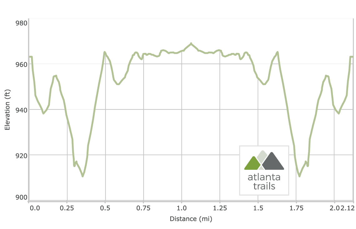
The trail connects Mason Mill Park and Medlock Park in Decatur, crossing only a single, quiet neighborhood road. And the trail’s new northern extension runs creekside along Burnt Fork Creek, crossing scenic boardwalks as it meanders northbound to N Druid Hills Road. The trail’s first half mile is moderately challenging, descending into a railway corridor and then rolling through a hilly forest. The trail’s second half levels, traversing a raised boardwalk that meanders through the forest’s shady hardwood trees.

While it’s not an overly long run, it’s a stunningly scenic one, with scenic treetop views and historic structures dotting the suburban landscape. And for a longer workout, the trail is easily doubled for a great 10k workout.

South Peachtree Creek Trail at Mason Mill Park: the run
The trail departs its western trailhead near the park’s tennis center (view maps and driving directions), running a paved trail to a trestle bridge over an active rail line. The trail crosses the bridge, pivoting twice to descend elevation on a boardwalk to the ruins of the Decatur Waterworks, now covered in colorful graffiti.

The trail crosses a bridge spanning Burnt Fork Creek before gaining elevation, winding on pavement through a wooded forest. Unpaved side trails depart the paved trail, visiting South Peachtree Creek and its tributaries, and offer a chance to add some off-pavement mileage to the run.
The trail meets the creek at .6 miles, and the trail’s surface turns to a wooden boardwalk. The trail runs through the forest on its raised wooden platform, catching shade beneath the forest canopy and skirting the backyards of nearby neighborhoods.

The trail crosses a neighborhood road at just under one mile, running the final, level stretch to the ballfields of Medlock Park before turning to return to the trailhead. The run reaches 2.1 miles after climbing the train trestle boardwalk. Reaching the Mason Mill Park trailhead, the run makes a northbound trek, winding just over three-quarters of a mile to the trail’s current end at North Druid Hills Road, and then doubles back to the trailhead, reaching the trailhead and completing the adventure.


Please Remember
Always leave no trace, pack out everything you pack in, and if you see trash, pick it up and pack it out.
Stay on the marked trail, tell someone where you're going, pack safety and wayfinding essentials, and don't rely on a mobile phone to find your way. Please always practice good trail etiquette. And before you go, always check the trailhead kiosk, official maps, and the park or ranger office for notices of changed routes, trail closures, safety information, and restrictions.
South Peachtree Creek Trail Map, Directions & Details

Driving Directions
Parking
Free parking is available at Mason Mill Park.
GPS Coordinates
33.806067, -84.305250 // N33 48.364 W84 18.315
Elevation Profile