Run, bike or walk the Towpath Trail on the banks of the Augusta Canal and Savannah River, following a broad, level trail to historic sites and beautiful views. The trail is a great spot for a scenic, easy, distraction-free run, a great bike ride or a relaxing sunrise stroll near downtown Augusta.
(round trip)
moderate
friendly
LOCATION:Augusta, Georgia
PACK:our Osprey day pack and our hiking gear list
The early morning sun floats skyward from the horizon, coloring the world in a golden glow. The Savannah River tumbles, churns and glides over its wide, rocky bed. The historic Augusta Canal flows parallel to the river, its waters glassy and reflective of the colorful sky overhead. Otters, turtles, deer, fish, and birds take flight, scurry, swim and graze the river and canal’s banks and waters, a flurry of morning activity. Scores of historic buildings, bridges, and sites line the banks. And, running straight and level, the Towpath Trail runs a course through it all, wandering a narrow stretch of land with its namesake canal to the west, and the beautiful Savannah River to the east.
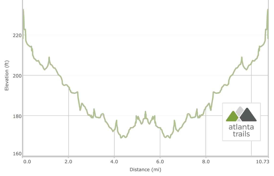
The packed-dirt Towpath Trail spans just under six miles. The trail travels south from the canal’s headgates at Savannah Rapids Park south to a tumbling waterfall and aqueduct at Rae’s Creek Aqueduct Park.

The trail runs nearly level and generously broad, once a towpath for draft animals to pull barges upstream on the canal. The trail visits wildlife habitats and historic sites along its length, traveling over locks and bridges, through scenic, moss-draped riverside forests, and past wide-open clearings with beautiful views of the canal and river. It’s one of Augusta’s most popular recreation areas, and equally perfect for a bike ride, urban hike, daily run, or a tour through the city’s history.
The Augusta Canal was built in the mid-1800s, and served as a source of power, drinking water and transportation for the city of Augusta. The canal led to the city’s rise as a manufacturing powerhouse in the late 19th and early 20th centuries, but had fallen into neglect by the mid-1900s. Local residents and organizations led a major cleanup effort and revitalization of the canal in the 1980s. It’s now Augusta’s most popular running, kayaking, biking, and recreation area, and is officially designated the Augusta Canal National Heritage Area, Georgia’s first NHA.

Augusta Canal Towpath Trail: the details
The adventure begins at a trailhead at the Savannah Rapids Park (view maps and driving directions), descending on a paved trail and passing a small waterfall on Reed Creek. (Prefer to bike, but didn’t bring your own? The Bicycle Peddler, located at the trailhead, offers well-tuned bikes, wonderful service, and great rental rates.)
The trail crosses the canal on a large steel and wood bridge, catching beautiful views of the canal’s headgates upstream. After crossing the bridge, the route veers left on the packed-dirt Towpath Trail, following the trail northbound. The trail reaches the enormous, historic wooden headgates and the Savannah River’s rapids at .35 mile, catching broad, sweeping views of the river and canal.

After soaking in the views, the route flips in reverse, following the Towpath Trail southbound through a shady forest draped in tendrils of Spanish moss. The levee is narrow along this stretch, offering beautiful views of the canal and the Savannah River. Many types of wildlife make their homes along the canal; watch for birds, turtles, otters, and other animals along the banks.
At 1.15 miles, the trail crosses a small bridge over the canal’s locks, once used to regulate the flow and water level in the canal. The trail passes a side trail to the site of a fish camp and squatter’s shack at 1.7 miles, and ducks under the towering, concrete I-20 underpass at 2.5 miles.
The trail enters a broad, grassy clearing at 3 miles, a perfect spot to stop for a water break and take in the sweeping views of the shoaling river. Just after passing the clearing, the trail crosses another set of locks, passing their large, crimson-colored metal gears.
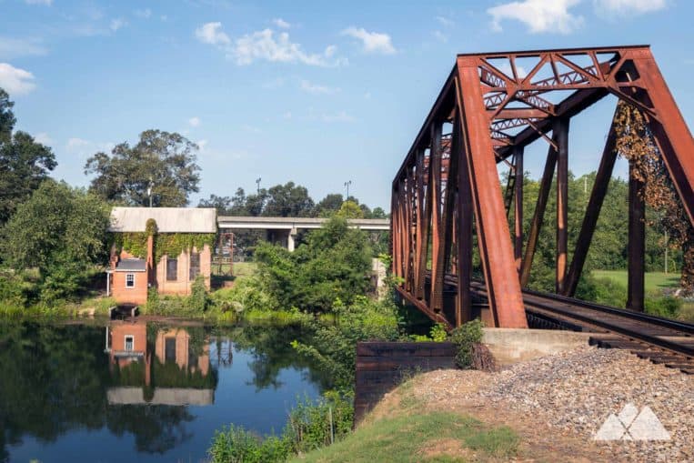
The Towpath Trail continues its southerly journey, catching plentiful canal and river views. The trail exits tree cover at 4 miles, traveling the canal’s sun-drenched grassy banks at the water pump station. Just past the water pump station, the trail crosses a set of railroad tracks that span the canal over a large steel bridge.
Rae’s Creek Aqueduct Park
The trail reaches the Long Spillway at 4.7 miles, crossing the gated spillway channel allowing water to pass from the canal to the Savannah River. The trail skirts the perimeter of Rae’s Creek Aqueduct Park, the site of a historic stone aqueduct and a beautiful, cascading waterfall.
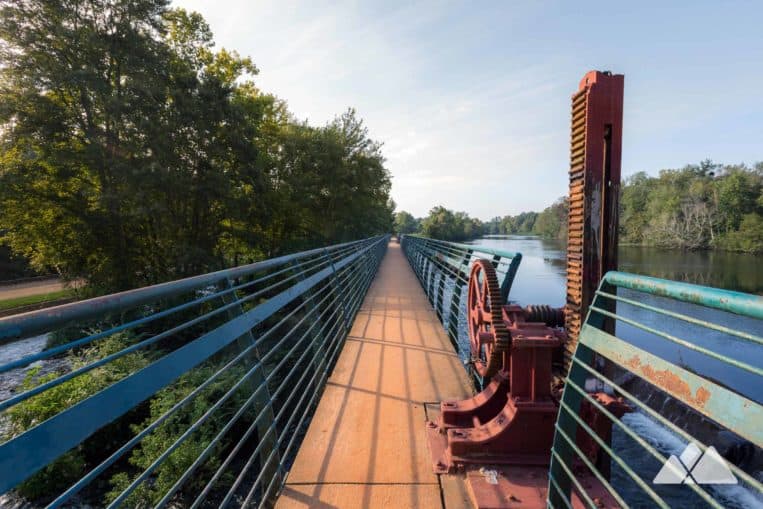
After passing Aqueduct Park, this route catches beautiful views of the canal from a large bridge at the Olmstead Bulkhead Gate. Just across the canal, the Lake Olmstead Trailhead offers restrooms, showers, and water fountains for a mid-run (or cycle) break.
The adventure turns around at the Olmstead Bulkhead bridge, retracing its outbound route to the trailhead on the Towpath Trail, a slightly uphill return. Make an optional loop through Aqueduct Park, veering eastward on a side trail from the Olmstead Bulkhead, to catch views of the beautiful waterfall on Rae’s Creek and re-joining the Towpath Trail just past the Long Spillway. After crossing the bridge over the canal at Reed Creek and re-entering Savannah Rapids Park, this view-packed bike ride or long distance run finishes at just under 11 miles.

More outdoor adventures near Augusta
Just south of the city, the exceptionally beautiful Phinizy Swamp Nature Park offers more than 14 miles of unpaved trails perfect for hiking, trail running, or biking. The swamp is home to a staggering abundance of wildlife, and filled with lush vegetation and moss-draped trees on the banks of the Savannah River.

Please Remember
Always leave no trace, pack out everything you pack in, and if you see trash, pick it up and pack it out.
Stay on the marked trail, tell someone where you're going, pack safety and wayfinding essentials, and don't rely on a mobile phone to find your way. Please always practice good trail etiquette. And before you go, always check the trailhead kiosk, official maps, and the park or ranger office for notices of changed routes, trail closures, safety information, and restrictions.
Augusta Canal Towpath Trail Map, Directions & Details

Driving Directions
Parking
Free parking is available at Savannah Rapids Park.
GPS Coordinates
33.547917, -82.037800 // N33 32.875 W82 02.268
Elevation Profile