


Hike the Appalachian Trail southbound from Dicks Creek Gap, climbing to stunning views of Lake Burton from the summit of Powell Mountain.
(round trip)
difficult
friendly
LOCATION:Appalachian Trail near Hiawassee, Georgia
PACK:our Osprey day pack and our hiking gear list
OFFICIAL MAP: Appalachian Trail, Trails Illustrated Map (find it at Trailful Outdoor Co.)
Mile for mile, this isn’t a particularly long day hike on the Appalachian Trail, but it sure is a rewarding one. Stretching just over two and a half miles each way, this hike follows the AT southbound from Dicks Creek Gap near Hiawassee. It explores a beautiful, lush forest under a canopy of tall hardwoods. And while the outbound hike is a workout, climbing nearly continuously from the gap, the lofty summit views from Powell Mountain make the workout so worthwhile.
Powell Mountain is a sun-soaked, rocky peak just off the AT in North Georgia. It offers wide views of Lake Burton and many rolling, blue-hued Appalachian summits on the distant horizon. The summit view is the kind that you almost have to tear yourself away from, making it the perfect mid-hike resting spot.


Dicks Creek Gap to Powell Mountain: the hike
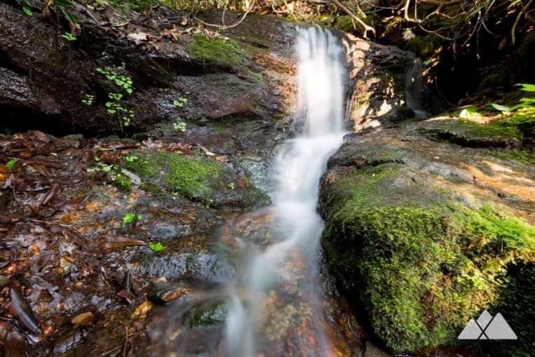
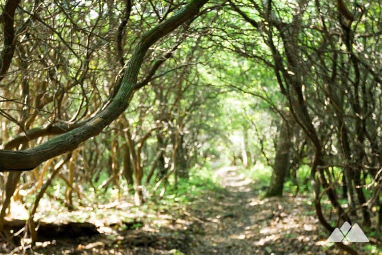
The adventure begins at the Dicks Creek Gap trailhead (view maps and driving directions) just east of Hiawassee. It crosses GA Highway 76 to hike south from the trailhead parking area. The route follows the iconic white rectangular blazes of the Appalachian Trail as it ventures southbound, climbing elevation through a towering, spindly hardwood forest. The hike passes a small, trickling waterfall as the ascent continues.
Several old-growth trees flank the trail, their massive trunks dwarfing the surrounding forest. Lush, green vegetation borders the trail, and enormous ferns and wildflowers frame the sides of the white-blazed path.
The trail levels briefly at a half-mile, passing a large campsite on the left. The hike resumes the climb, making a short descent and winding through switchbacks over the next third of a mile. The trail passes a seasonally-available water source at just under a mile, skipping over a shallow creek and passing another campsite at 1.2 miles.
The hike unwaveringly ascends, climbing nearly due south. The AT climbs through a thick grove of twisted, gnarled mountain laurel, switching back sharply at just under two miles and veering northwest.
After cresting at 2.25 miles, the trail dips elevation through McClure Gap, and then resumes the climb. Nearing the peak of Powell Mountain, the hike reaches a side trail that departs to the left at 2.5 miles. The trail is marked by a small wooden “vista” sign, and blue trail blazes mark the side trail (though the first blazes are not immediately visible from the sign).
This hike departs the white-blazed Appalachian Trail, following the side trail a quarter-mile southeast to a rocky overlook. Sweeping, long-range views unfold to the south.
On the horizon, the waters of Lake Burton, Lake Seed, and Lake Rabun nestle into the rolling blue-hued southern Appalachian Mountains. Black Rock Mountain is visible in the distance. The sun-drenched, rocky slope is a perfect place to grab a snack before the return hike to the trailhead.
Departing the overlook, the route flips in reverse, retracing its outbound steps to the trailhead. Remember that calf-burning ascent on the outbound? The return hike is almost blissfully downhill. The hike reaches Dicks Creek Gap at 5.2 miles, completing the adventure.

Dicks Creek Gap to Powell Mountain: camping
Several trailside campsites flank the trail’s sides, and all are available first-come, first-camp. Be sure to make camp early in peak hiking season and on weekends. Whether you’re spending the night or passing through, please always remember to leave no trace to preserve the beauty of this stunning stretch of Georgia forest.
AFTER THE ADVENTURE
Have daylight and energy to burn? Head into town and stop by our hiking outfitter shop in Hiawassee, Trailful Outdoor Co. Find your next adventure on our wall full of local trail info and tips, featuring over 70 our personal favorites in North Georgia and Western NC. We’re a full-service hiking outfitter shop, featuring a full range of our favorite backpacking and hiking gear and apparel, including our crew’s trail-tested favorites from KUHL, Osprey, MSR, Marmot, NEMO, and many more. Stop by to say hello… we’d love to see you!

Please Remember
Always leave no trace, pack out everything you pack in, and if you see trash, pick it up and pack it out.
Stay on the marked trail, tell someone where you're going, pack safety and wayfinding essentials, and don't rely on a mobile phone to find your way. Please always practice good trail etiquette. And before you go, always check the trailhead kiosk, official maps, and the park or ranger office for notices of changed routes, trail closures, safety information, and restrictions.
Dicks Creek Gap to Powell Mountain Map, Directions & Details

Love the trail?
This trail is maintained thanks to the hard work of countless volunteers and donations from supporters of the Georgia Appalachian Trail Club. Please support them by making a donation or joining a volunteer day. Let's work together to keep these fantastic trails maintained and open for use!
Driving Directions
Parking
Free parking is available at the Dicks Creek Gap trailhead.
GPS Coordinates
34.912167, -83.618967 // N34 54.730 W83 37.138
Elevation Profile


