


Hike to Tray Mountain from Unicoi Gap on the Appalachian Trail, climbing to summit views at Rocky Mountain, and exploring a lush North Georgia forest filled with wildflowers and mountain laurel.
(round trip)
difficult
friendly
LOCATION:Appalachian Trail near Helen, Georgia
PACK:our Osprey day pack and our hiking gear list
OFFICIAL MAP: Appalachian Trail, Trails Illustrated Map (find it at Trailful Outdoor Co.)
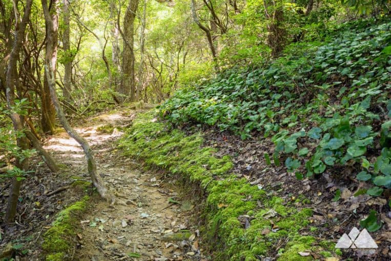
As part of its northbound, 2000+ mile hike from Springer Mountain to Maine, the Appalachian Trail treks some of North Georgia’s most beautiful terrain. This ten-mile round trip on the AT scales to some stunning views from two mountain summits, Rocky Mountain and Tray Mountain. It crosses trickling creeks, climbs through a mossy, boulder-filled forest and tunnels through gnarled, low-canopy forests filled with mountain laurel and wildflowers. And along the way, the hike crosses through some abundantly beautiful, lush Georgia forest.
 Hike to stunning views from the Tray Mountain summit on the Appalachian Trail
The route departs from Unicoi Gap, one of a few paved trailheads on Georgia’s 75 mile stretch of the Appalachian Trail. It’s a great workout, climbing and falling a combined 6600 feet over its ten-mile journey to Rocky Mountain, Indian Grave Gap, Tray Mountain and back. It’s by far one of our favorite stretches of the Appalachian Trail in Georgia, and it’s an equally great, challenging day hike or a quick overnight backpacking trip.

Appalachian Trail Tray Mountain from Unicoi Gap: the hike
The hike departs from the Unicoi Gap parking area on GA 75 (view maps and driving directions), trailing eastbound and ascending rustic wooden log stairs. Following the iconic, rectangular white blazes of the Appalachian Trail, the hike begins a steady ascent, crossing several trickling springs and climbing through a rocky, boulder-filled terrain.
The hike crosses a small creek, trailing through a grove of rhododendron and passing a campsite at .6 miles. The Appalachian Trail passes the blue-blazed Rocky Mountain Trail at .85 miles, arcing sharply southbound and making a final climb to the summit of Rocky Mountain.
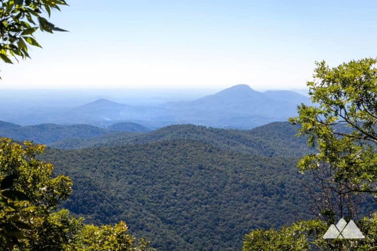
The hike crests Rocky Mountain at 1.3 miles, catching views of Yonah Mountain and the rolling landscape of the southern Appalachian Mountains. Several off-trail campsites (located on a blue-blazed side trail) offer excellent near-summit camping.
The Appalachian Trail catches a few more high-elevation views before making a steady, southeast-bound descent. The hike drops elevation through a fern-filled forest, descending rustic stone stairs through groves of gnarly-branched mountain laurel on Rocky Mountain’s lower elevations.
The hike reaches Indian Grave Gap at 2.5 miles, crossing a gravel road. The AT climbs from Indian Grave Gap, ascending through a lush forest filled with moss, the pungent scent of leafy galax, and dense mountain laurel groves.
From here, it’s a nearly continuous ascent to Tray Mountain. The Appalachian Trail crosses a small spring at 3.2 miles just before crossing the gravel-paved Tray Mountain Road. The hike passes a small campsite at 3.3 miles and tunnels through a dense mountain laurel canopy before reaching a broad, grassy glen at 3.5 miles. Nicknamed the ‘Cheese Factory,’ the glen is a prime Appalachian Trail campsite, loved for its ample grassy tent sites and a nearby spring. It’s the historic site of a dairy from the 1800s, though little evidence of the original cheese factory remains.
The AT continues its climb, switching back through a lush, green forest filled with tall wildflowers. The hike passes a wide rock slab at 4 miles, catching the first views of nearby Tray Mountain from the rock overlook. There’s an on-trail campsite here as well, offering some spectacular morning views.
The hike reaches Tray Gap at 4.2 miles, crossing the gravel-paved road. The trail switches back sharply, climbing into the rugged Tray Mountain Wilderness and making a final ascent to the summit. (What is Wilderness, and why is it important? Read more in our guide to Wilderness areas in the South.)

A small rock outcrop offers near-summit views at 4.8 miles. The Appalachian Trail summits Tray Mountain at 4.95 miles, reaching the angular, rocky mountaintop. Views from the lofty, 4429′ mountaintop extend to the north and the south.
Departing Tray Mountain, this hike turns to retrace its outbound steps on the Appalachian Trail, descending through Tray Gap and Indian Grave Gap. The route makes a final climb to the Rocky Mountain summit, scaling 850 feet of elevation before making a continuous descent to Unicoi Gap. The adventure reaches the Unicoi Gap trailhead at just under 10 miles, completing the hike.

More Appalachian Trail adventure from Unicoi Gap
After crossing the highway, the AT climbs steeply from Unicoi Gap to Blue Mountain and treks across a wildflower-filled ridge. Hike the Appalachian Trail to the Blue Mountain AT shelter and Chattahoochee Gap to visit a small, trickling spring that eventually becomes the mighty, wide-flowing Chattahoochee River.
Or for a slightly milder five-miler at Rocky Mountain, hike the Appalachian Trail and Rocky Mountain Trail Loop, scaling Rocky Mountain and looping through the wildflower-filled Indian Grave Gap to return to Unicoi Gap.

Please Remember
Always leave no trace, pack out everything you pack in, and if you see trash, pick it up and pack it out.
Stay on the marked trail, tell someone where you're going, pack safety and wayfinding essentials, and don't rely on a mobile phone to find your way. Please always practice good trail etiquette. And before you go, always check the trailhead kiosk, official maps, and the park or ranger office for notices of changed routes, trail closures, safety information, and restrictions.
Appalachian Trail: Unicoi Gap to Tray Mountain Map, Directions & Details

Love the trail?
This trail is maintained thanks to the hard work of countless volunteers and donations from supporters of the Georgia Appalachian Trail Club. Please support them by making a donation or joining a volunteer day. Let's work together to keep these fantastic trails maintained and open for use!
Driving Directions
Parking
Free parking is available at the Unicoi Gap trailhead.
GPS Coordinates
34.801417, -83.742983 // N34 48.085 W83 44.579
Elevation Profile


