


Hike a difficult 12-mile adventure on the Conasauga River Trail, following and fording a tumbling river from this trail’s northern trailhead. It’s a wet, river-filled adventure in Georgia’s remote, beautiful Cohutta Wilderness.
(round trip)
difficult
for some dogs
LOCATION:Cohutta Wilderness near Chatsworth, Georgia
PACK:our Osprey day pack and our hiking gear list
OFFICIAL MAP: Nat Geo 777 Trails Illustrated Map (find it at Trailful Outdoor Co.)
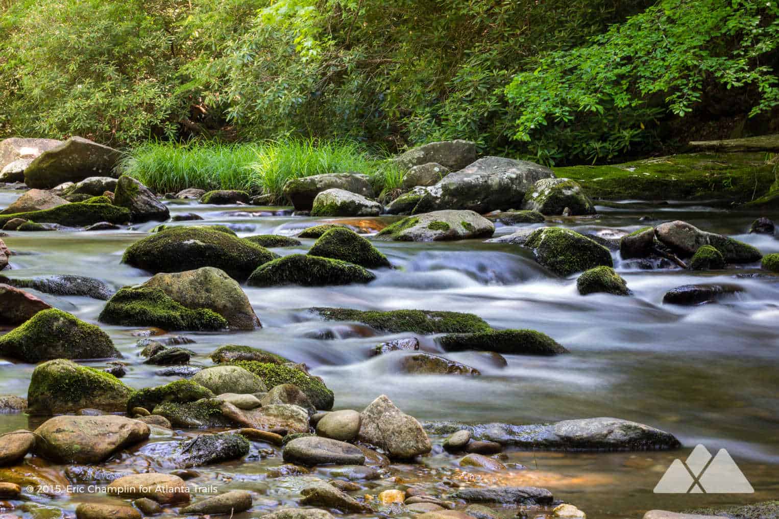
First: this trail’s upper section is a challenging hike. The trail’s northern half requires 20 major river crossings each way, where the river flows deep and in fast-moving currents. Downriver from the Conasauga River’s tamer southern half, the river’s flow on the trail’s northern half is significantly deeper, faster and potentially dangerous, especially after a recent rain.
That said, this hike treks through exceptionally beautiful, pristine, seldom-traveled forest in remote stretches of the Cohutta Wilderness. It’s a fantastic summer hike: with 40 roundtrip river crossings, you’re guaranteed to get wet, and the river’s crystal-clear water stays shockingly chilly, even in the heat of summer. Multiple campsites along the trail make for a great backpacking adventure (especially when combined with the Conasauga River Trail’s southern half, making a 12.6-mile one-way or a 25.2-mile roundtrip).

This challenging 12-mile adventure begins at the trail’s northern trailhead near the Georgia-Tennessee border, trekking south and following the Conasauga upriver. The hike descends sharply from the trailhead to reach the banks of the Conasauga River before commencing the first of many river fords as the trail alternately follows and then dives through the river. It’s a difficult but fun hike that requires patience and experience: many river crossings are unmarked, there are no bridges, trail blazes are scarce and in a wilderness this vast and remote, it’s easy to get turned around. A handheld GPS, compass and a topographic trail map of the Cohutta Wilderness (available at our Trailful Outdoor Co. shop) are highly recommended. Hike, and master, the other river trails in the Cohutta Wilderness, like the Jacks River Trail, lower Conasauga River Trail and the Emery Creek Trail, before attempting this hike.
Bottom line: hike safely, pack well, and in the case of rising river levels after a rain, anticipate spending an unanticipated night (or nights) in the wilderness. Don’t attempt to cross the river if safety is a concern. And don’t forget to have fun: this trail is a water-filled and stunningly beautiful adventure.

Upper Conasauga River Trail: the hike
The adventure begins at the trail’s northern trailhead off the graveled FS-17B, deep in the northern stretches of the Cohutta Wilderness (view maps and driving directions, and as always, follow posted regulations at the signed trailhead). The hike follows an old road bed north before quickly turning right at .1 mile, following the Conasauga River Trail eastbound into a lush, green forest. The trail descends through a creek valley filled with fern and rhododendron, catching the first sound (and an occasional cool breeze) from the river at .7 mile. The trail continues its descent, reaching the Conasauga River at 1.15 miles and making the first of many river crossings.
The river’s flow varies from mild to wild on the hike, alternating between calm, glassy stretches between grass-filled banks and tumbling, whitewater-filled waterfalls in the riverbed’s more rugged areas. Each trail crossing requires a bit of planning and consideration: spotting the trail on the river’s opposite bank can be tricky, and finding the simplest, most shallow and safest route on each crossing requires some surveying of the river’s flow. And the riverbed’s rocks are often slippery.
The trail crosses a creek at 1.4 miles, passing a campsite. Tall, angular rock outcrops border the trail as it follows the terraced, former route of a logging railway. The trail makes its second Conasauga River crossing at 1.6 miles, just downstream of a large, stacked-stone wall – a former bridge for the rail line.
The trail makes its third and fourth river crossings at 1.7 and 1.8 miles, following a pebble-lined dry creek bed after crossing four before darting back into the forest. (Some careful trail scouting is usually required here: the trail can be especially hard to spot in this stretch.) The trail rises above the river through a stretch of rhododendron-filled forest (watch for blooms in early summer) before making its fifth and sixth (often difficult) river crossings. The river spills, tumbles and thunders over whitewater and waterfalls at 2.5 miles as the trail treks past chiseled rock outcrops and passes several campsites.
After its seventh crossing at 2.9 miles, the Conasauga River Trail treks an extended length on land, crossing a small stream. The river crossings resume at 3.7 miles as the trail dives through crossings 8 through 12, a quick series of five crossings in under .4 mile. The trail begins a steady but relatively gentle elevation climb, trailing beside a boulder-filled side channel before making a quick succession of four river crossings (numbers 13-16) along a meandering stretch of the river. At 5.2 miles, a tributary, Thomas Creek, tumbles into the Conasauga in a series of small, cascading waterfalls.

Continuing its meandering, southbound journey, the trail fords the river at 5.4 miles, making its 18th crossing, before hiking through a deep-cut ravine. The hike crosses the river again at 5.9 miles, upstream of a tumbling waterfall, the trail’s 19th river ford. The trail makes its final, 20th ford through the river’s boulder-studded bed at 6 miles, reaching a campsite. Near the campsite, the Hickory Creek Trail veers to the southwest. The Conasauga River Trail veers to the southeast, hiking an additional 6.6 miles to the trail’s southern trailhead at Betty Gap.

The return
This hike turns northbound, retracing its outbound steps to return to the trail’s northern trailhead. The return trek is primarily downhill as the hike carefully crosses the Conasauga River through an additional 20 fords, following the river downstream. After fording the final crossing at 10.9 miles, the trail veers from the river’s banks, making a nearly unrelenting climb to the trailhead. The hike reaches the trailhead at 12 miles, completing the adventure.
Because this area is so remote, challenging, and the trails are sometimes sporadically blazed or not marked at all, always tell someone where you’re going and pack an official paper map and wayfinding essentials, such as a GPS and compass (and know how to use them if you’re lost). Always pack emergency essentials. And it’s always best to avoid trails along the rivers and creeks in the weeks following a heavy rain.
(What is Wilderness, and why is it important? Read more in our guide to Wilderness areas in the South.)

Please Remember
Always leave no trace, pack out everything you pack in, and if you see trash, pick it up and pack it out.
Stay on the marked trail, tell someone where you're going, pack safety and wayfinding essentials, and don't rely on a mobile phone to find your way. Please always practice good trail etiquette. And before you go, always check the trailhead kiosk, official maps, and the park or ranger office for notices of changed routes, trail closures, safety information, and restrictions.
Conasauga River Trail - Upper Half Map, Directions & Details

Love the trail?
This trail is maintained thanks to the hard work of countless volunteers and donations from supporters of the Chattahoochee National Forest. Please support them by making a donation or joining a volunteer day. Let's work together to keep these fantastic trails maintained and open for use!
Driving Directions
Parking
Free parking is available at the USFS trailhead. The northern Conasauga River trailhead is accessed via gravel Forest Service roads.
GPS Coordinates
34.938667, -84.658500 // N34 56.320 W84 39.510
Elevation Profile


