


Hike a short but sweet quarter mile to the tumbling cascades of Issaqueena Falls, one of South Carolina’s most beautiful waterfalls located just across the Georgia border.
(round trip)
difficult
friendly
LOCATION:near South Carolina's Sumter National Forest
PACK:our Osprey day pack and our hiking gear list
It’s big on beauty, but short on distance: the quarter-mile hike to Issaqueena Falls makes for a fantastic family-friendly adventure. The hike explores a several-hundred-foot tall cascading waterfall at the edge of South Carolina’s beautiful Sumter National Forest, catching views from an observation deck before scrambling to the base of the falls.

With easy access and abundant beauty comes popularity, so the trail does get some traffic on fair-weather weekends. And its proximity to the nearby Stumphouse Tunnel, a historic railroad tunnel from the mid-1800s, makes this waterfall hike a popular one. Seeking some solitude at the falls? Arrive in the morning for a chance at having the falls to yourself – and some beautiful golden morning light on the trail.


Issaqueena Falls: the hike
The adventure begins at a trailhead at Stumphouse Mountain Park just northwest of Walhalla, SC (view maps and driving directions). The hike departs southbound from the parking area and quickly crosses a small wooden covered bridge over Cane Creek.
The level trail continues south for several hundred yards, winding through thickets of leathery-leafed rhododendron and soon reaching a wooden observation platform that overlooks the enormous waterfall.
To reach the base of the falls, a steep but short trail descends below the observation deck to a rewarding vantage point that gives the waterfall a great sense of scale. This section of the trail is often somewhat muddy and slippery, so footwear with good tread is useful in navigating the steep downhill.
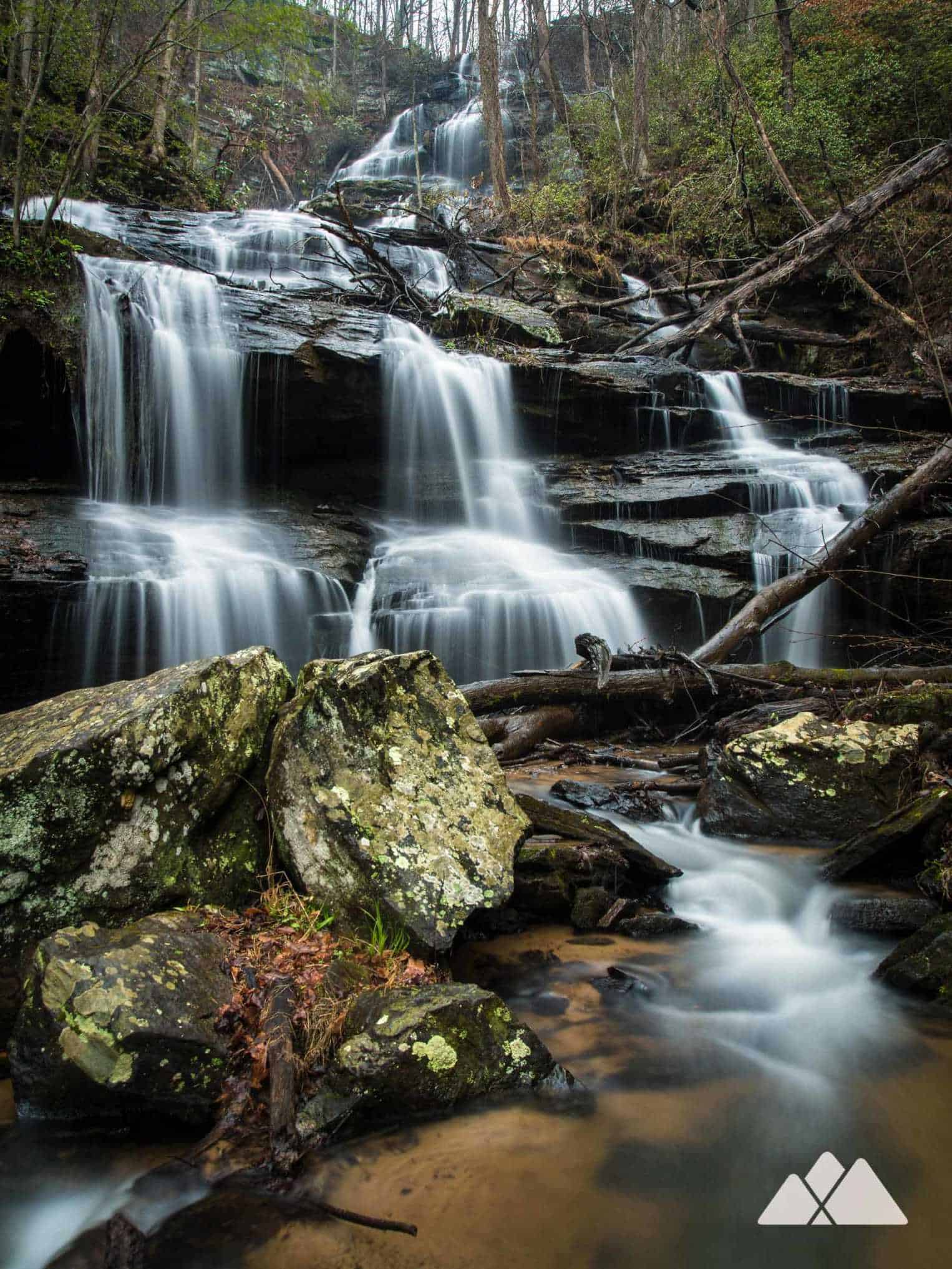
The base of the main falls makes for a great spot for a picnic – or simply just relaxing and admiring the beauty of the cascade. Although Cane Creek flows quite narrow upstream, the waterfall beautifully disperses over ledges and boulders to form a voluminous cascade that is exceptionally scenic, especially after some rain.
A narrow trail continues about 30 feet further alongside the waterfall, where Cane Creek begins to settle back to its meandering state. This section of trail is just as tricky (if not more so) than the original descent from the observation platform, and gnarly, uneven roots cover the trail. Tread carefully!
The return route to the trailhead follows the outbound hike in reverse, climbing up to the observation deck and through the covered bridge. The hike reaches the trailhead at a quarter mile, completing the adventure.

Nearby adventures
Several of our favorite adventures lie just across the state line in Georgia. Follow a particularly scenic stretch of the Chattooga River Trail along a broad, clear-flowing stretch of the Chattooga, one of the South’s few wild and unaltered rivers. The nearly-level hike begins at Russell Bridge on the South Carolina / Georgia border, visits the remains of a historic homestead, and ends at the river’s ultra-scenic river banks at Adeline Ford. Or for a shorter adventure, hike the Dicks Creek Falls Trail to the Chattooga’s banks, catching beautiful views of an enormous waterfall that tumbles into the river.

Please Remember
Always leave no trace, pack out everything you pack in, and if you see trash, pick it up and pack it out.
Stay on the marked trail, tell someone where you're going, pack safety and wayfinding essentials, and don't rely on a mobile phone to find your way. Please always practice good trail etiquette. And before you go, always check the trailhead kiosk, official maps, and the park or ranger office for notices of changed routes, trail closures, safety information, and restrictions.
Issaqueena Falls Map, Directions & Details

Driving Directions
Parking
There's a $2 parking fee required at Stumphouse Tunnel Park and the Issaqueena Falls trailhead.
GPS Coordinates
34.807600, -83.121517 // N34 48.456 W83 07.291
Elevation Profile


