Hike the Jones Bridge Park Trail on the Chattahoochee River to the remains of an old, heisted bridge, through a scenic forest and to beautiful river views in metro Atlanta.
(round trip)
moderate
friendly
LOCATION:Chattahoochee River near Atlanta, Georgia
PACK:our Osprey day pack and our hiking gear list
This scenic hike at Jones Bridge Park explores the Chattahoochee River’s scenic banks in the city of Johns Creek, visiting the remnants of a turn-of-the-century bridge and a beautiful, riverside forest. A moderate hike (or great trail run) on this under-five-mile loop scores views of the river’s whitewater shoals and its lush, wildflower and wildlife-filled forest.

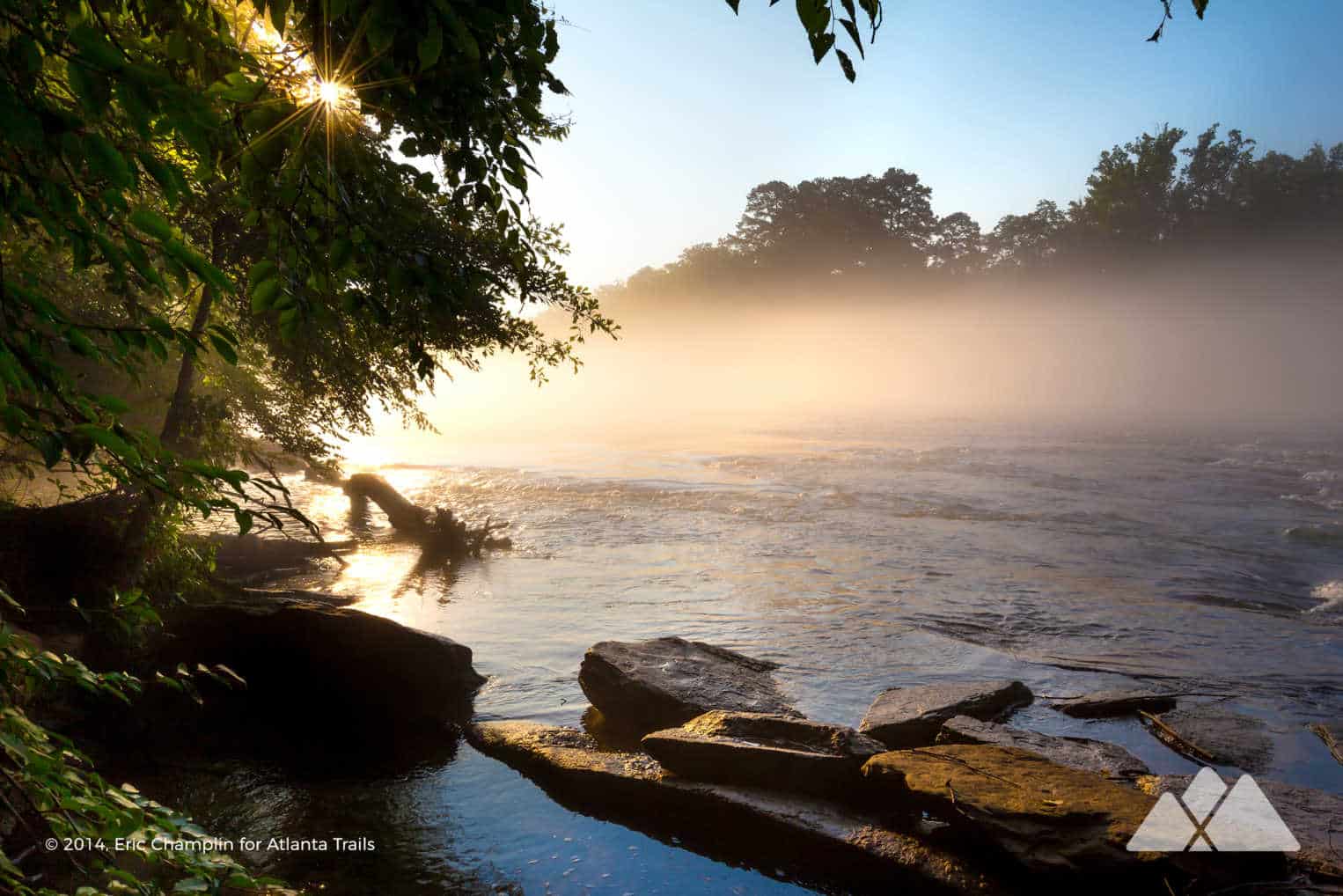
Cool, early mornings are our favorite time to hike this trail, when golden sunrise light mixes with the occasional, flowing fog that follows the river’s currents. The park makes for a great adventure in just about any weather and every season, though, thanks to the trail’s abundant views of the Chattahoochee River and the park’s namesake, mysterious bridge.
NOTE: unfortunately, the bridge remains have collapsed into the river as of January 2018, and the old bridge no longer is visible on this hike.

Jones Bridge Park: the hike
The adventure departs from the park’s trailhead (view maps and driving directions), venturing north from the parking area and skirting around a metal gate to follow a gravel roadbed. The trail arcs eastbound, gently rolling elevation before approaching the Chattahoochee River and crossing a small stream. The trail reaches the metal remains of Jones Bridge at .45 mile. The bridge was built in 1904, and was dismantled and largely stolen in the 1940s. The bridge’s vibrantly-painted shell and pilings are all that remain.

Departing the bridge, the hike turns west, following the Chattahoochee River downstream as it contours the river’s banks. The trail passes a series of whitewater shoals at .6 mile, where the river meanders through large boulders and angular rock outcrops that punctuate the river’s bed. The trail passes a boat launch at .75 mile, diving into dense forest on the river’s banks. The trail crosses a large wooden suspension bridge at 1 mile.
The trail crosses the park’s paved boat ramp at 1.25 miles before crossing a second wooden suspension bridge and diving back under the shady forest canopy. Side trails depart to the right, visiting the wide-flowing Chattahoochee River and its forested banks.
The trail leaves the river at 1.5 miles, crossing a gravel road and climbing wooden stairs westbound to gain elevation in a vibrantly green, verdant forest. Deer are a common sight here on the trail, especially in early morning and late evening. A network of trails crisscross throughout this section of the park; this route veers left through the trail intersections, hiking southbound to return to the Chattahoochee River’s shore.
The trail reaches the river’s banks after crossing a cleared, unpaved road at 2 miles, arcing southwest to follow the river downstream. The trail reaches the southern end of the park, looping westbound away from the river’s banks. The hike meets a signed intersection at 2.75 miles, turning right to cross a mulched road at 2.85 miles and pass through a densely-vegetated meadow.
The trail reaches the banks of a glassy lake at 3 miles, catching reflective views from its glassy surface. Several houses border the small lake on the opposite shore.

Departing the lake, the trail splits into a number of fragmented trails. This route takes a right at 3.1 miles, a left at 3.15 miles, and crosses a grassy, pine-filled flat before venturing straight through a 4-way trail intersection at 3.25 miles for the most direct route back to the main trail.
Reaching the outbound trail at 3.3 miles, the hike turns left, retracing its steps through the rolling forest northeast toward the trailhead. The trail traces the Chattahoochee River, hiking upstream and trekking across the park’s boat launch before reaching the trailhead at 4.6 miles, completing the adventure.

After the adventure
A few hours on the trail can definitely work up an appetite! After exploring Jones Bridge Park, head into nearby Johns Creek for a quick bite, local brew, hot coffee, or a frozen treat. Cool off and satisfy your sweet tooth with a trip to Where’s the Scoop, where you’ll find delicious rolled ice cream creations made from scratch daily using locally sourced dairy products. Try an ice cream taco, cookie sandwich, or mix your favorite toppings together. They even have ice cream for your four-legged adventure buddy! Or recharge with a little caffeine at Peach Coffee Roasters and grab a cup of brewed-to-order coffee, tea, or an iced latte. Their beans are all roasted in house, so they’re sure to be fresh and delicious!
If you’re in the mood to chill on the patio with a cold margarita check out Mavericks So-Cal Mexican Cantina. The So-Cal-inspired menu includes favorites like shrimp ceviche, fried avocado tacos, and braised brisket enchiladas. Or hang out at Johns Creek’s very own brewery: Six Bridges Brewing offers up a selection of craft beers perfect for enjoying on their dog-friendly patio, and they also host a variety of rotating food trucks offering a range of tasty dishes.
If you’ve got energy and time to spare, there’s plenty to do in the Johns Creek area. Visit the Autrey Mill Nature Preserve and wander over two miles of trails through a forest filled with native plants and wildflowers. The preserve also features the newly opened Farm Museum which highlights the history of the area. If you’re adventuring with your pup, hit up the Newtown Dream Dog Park complete with sprinklers, artificial turf, bridges, hoops, and tunnels. It’s sure to be a hit with Fido and friends!
For a cultural experience, visit the area’s newest attraction, the Johns Creek Tunnel, an immersive art exhibit that runs the entire length of the pedestrian underpass. The 130’ long art installation designed by mural artist Hanif Kureshi tells the story of Johns Creek and celebrates the history and diversity of the city.
More metro-Atlanta adventures on the Chattahoochee River
Crossed Jones Bridge Park off your bucket list, and looking for some more metro-area adventures on the ‘Hooch? Check out our top ten favorite hikes on the Chattahoochee River to explore rocky, view-packed bluffs, a grove of bamboo on the river’s banks, Civil War-era mill ruins, and a tumbling spillway waterfall.

Please Remember
Always leave no trace, pack out everything you pack in, and if you see trash, pick it up and pack it out.
Stay on the marked trail, tell someone where you're going, pack safety and wayfinding essentials, and don't rely on a mobile phone to find your way. Please always practice good trail etiquette. And before you go, always check the trailhead kiosk, official maps, and the park or ranger office for notices of changed routes, trail closures, safety information, and restrictions.
Jones Bridge Park Trail Map, Directions & Details

Love the trail?
This trail is maintained thanks to the hard work of countless volunteers and donations from supporters of the Chattahoochee National Park Conservancy. Please support them by making a donation or joining a volunteer day. Let's work together to keep these fantastic trails maintained and open for use!
Driving Directions
Parking
$5 day pass, or included with a Chattahoochee River NRA annual pass
GPS Coordinates
34.001517, -84.239817 // N34 00.091 W84 14.389
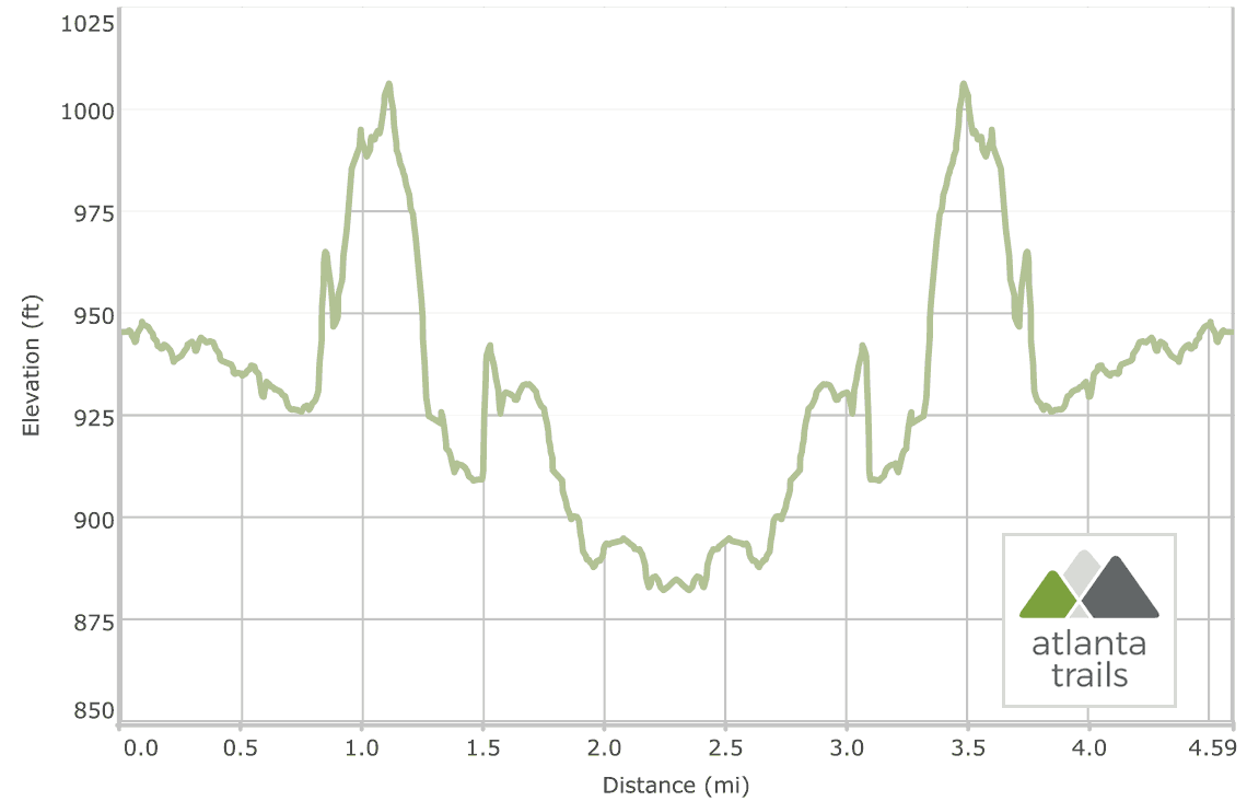
Elevation Profile