


Hike a scenic loop on the Laurel Ridge Trail and Cooper’s Furnace Trail, exploring a historic, stacked-stone iron furnace and climbing to high-elevation views of Allatoona Lake, the Etowah River and Allatoona Dam.
(round trip)
moderate
friendly
LOCATION:Lake Allatoona, near Cartersville, Georgia
PACK:our Osprey day pack and our hiking gear list
A historic iron furnace stands at the trailhead of the Cooper’s Furnace Trail, towering, pyramid-like, in stacked stone formation along the banks of the grassy Etowah River. The furnace is all that remains of the town of Etowah, a historic Georgia town mostly destroyed during the Civil War, and today lies flooded under the waters of Allatoona Lake. This visits the furnace and follows the Laurel Ridge Trail to catch some outstanding views of the river, lake, and several miles of scenic, stream-filled forest.
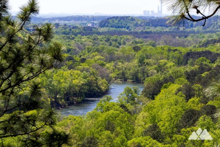
This two-trail duo near Cartersville packs a ton of scenic beauty (and history) into a short, relatively moderate two-mile loop. After visiting the historic remains of the furnace, the hike follows a trickling stream along a 19th-century railroad bed, passing a small beaver-dammed pond and climbing through a rocky forest. After crossing a long wooden span bridge, the hike climbs to an overlook near Allatoona Dam, scoring beautiful elevated views of the lake, the Etowah River Valley, and the stacked-stone furnace far below.
Fantastic views. Historic features. And several miles of moderate, well-maintained trail through a scenic, stream-filled, rocky forest. It’s a great, family-friendly day hike by itself – and an equally great cool-down after a hike on the nearby Pine Mountain Trail.

Laurel Ridge Trail: the hike
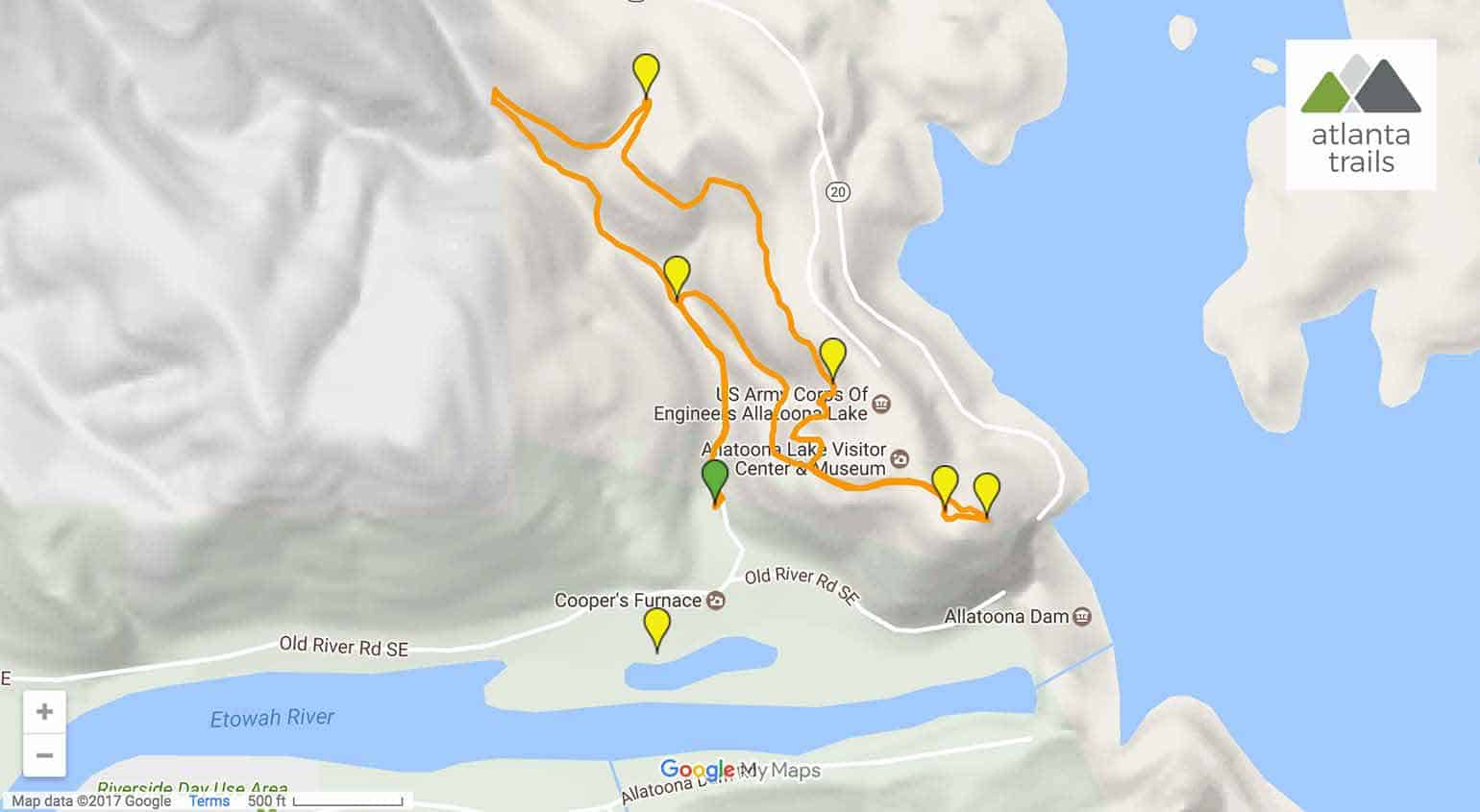
The hike departs from the shores of the Etowah River (view maps and driving directions), catching views of the wide-flowing, grassy river from the parking area. Pavilions and wide, grassy expanses make for a great post-hike picnic.
The Cooper Furnace trailhead is located near the towering remains of the stone furnace, just past a metal gate. The hike climbs from the trailhead, following a wide, gravel roadbed along a trickling stream. Less than .1 mile into the hike, a side trail departs to the left, leading to a short ridge overlooking the furnace. This route continues northbound, following the teal-blazed trail along the grassy, trickling creek.

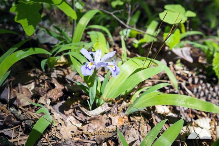
The hike reaches a small, glassy pond at .2 mile, veering left at the trail intersection. The trail climbs through a lush fern and wildflower-filled forest, ascending beside large, blocky rock outcrops and curving eastbound. The climb intensifies before the trail reaches an intersection at .6 miles.
This hike turns right at the intersection, following the red-blazed Laurel Ridge Trail and climbing to a series of wooden overlooks with views of the rocky, mixed pine and hardwood forest below. The hike is especially beautiful in spring when the trail’s thickets of mountain laurel bloom in abundance. The trail crosses a wooden span bridge over a deep-carved valley at .9 mile.
After crossing the bridge, the trail rolls elevation, meandering through the forest. The hike reaches the trail’s end at 1.1 miles, turning left on a gravel road to hike eastbound to the Allatoona Dam overlook. The trail passes a visitor center just before cresting at 1.25 mile, catching expansive, elevated views of the dam and deep, blue waters of Allatoona Lake to the east. To the west, an overlook offers gorgeous views of the Etowah River Valley and a high-elevation view of the furnace.

Looping back to the trailhead
Departing the overlook, the hike retraces its steps on the gravel road, hiking westbound. The route passes the junction with the Laurel Ridge Trail, continuing to follow the road as it winds and veers northwest. After a steady descent, the gravel roadbed reaches the beaver-dammed pond, turning left to hike the Cooper’s Furnace Trail to the trailhead.

Please Remember
Always leave no trace, pack out everything you pack in, and if you see trash, pick it up and pack it out.
Stay on the marked trail, tell someone where you're going, pack safety and wayfinding essentials, and don't rely on a mobile phone to find your way. Please always practice good trail etiquette. And before you go, always check the trailhead kiosk, official maps, and the park or ranger office for notices of changed routes, trail closures, safety information, and restrictions.
Laurel Ridge Trail and Cooper's Furnace Loop Map, Directions & Details
Love the trail?
This trail is maintained thanks to the hard work of countless volunteers and donations from supporters of the Chattahoochee National Forest. Please support them by making a donation or joining a volunteer day. Let's work together to keep these fantastic trails maintained and open for use!
Driving Directions
Parking
Free parking is available at the trailhead.
GPS Coordinates
34.165554, -84.733529 // N34 09.929 W84 44.013
Elevation Profile


