Hike Providence Canyon State Park, Georgia’s ‘Little Grand Canyon’, to explore colorful ravines and towering pinnacles of sandstone.
(round trip)
moderate
friendly
LOCATION:near Columbus, Georgia
PACK:our Osprey day pack and our hiking gear list
With views unlike any other in our state, this place is truly remarkable. The views are reminiscent of a southwestern US landscape. They’re colorful. And they’re certainly beautiful. Providence Canyon’s colorful, sculpted walls carve through a sandy, stream-filled landscape in the southwest corner of our state, near Columbus. This state park is one of our favorite destinations for a Georgia hike. Soft-bedded, sandy hiking trails wind and weave through its vibrantly-colored carved ravines and pinnacles. It’s an excellent spot for photography and exploration in an ever-evolving landscape of loose sandstone and trickling water.
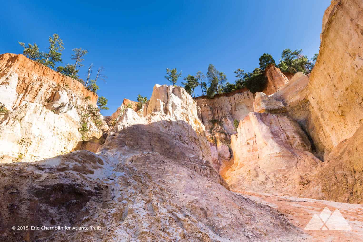
The park’s unusually sculpted, serpentine walls have earned its nickname as Georgia’s ‘Little Grand Canyon.’ The considerably larger cousin in Arizona certainly dwarfs Providence in scale and beauty. However, given its close distance from Atlanta, this local version is certainly hike-worthy. It’s one of the most unique Georgia’s State Parks, and one of our three favorite canyons in Georgia for a hike.
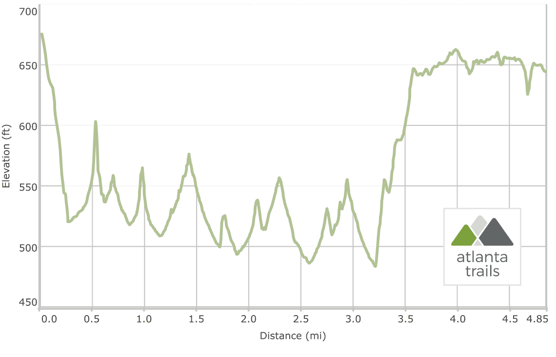
Providence Canyon State Park offers over ten miles of fantastic hiking trails. This hike follows the white loop, a just-under-five-mile adventure that scores views of the park’s highlights. The route catches outstanding views of the sculpted walls from above and explores its depths on a meandering path through nine numbered canyons down below.

Providence Canyon: the hike
The adventure begins at the park’s visitor center (view maps and driving directions), descending through a shady forest. The trail reaches the floor at .25 mile and follows a sandy riverbed into numbers 1-5.
The path on the floor of the ravine follows sandy stream beds, winding through vibrant orange, white, pink and deep purple sandstone walls. Over several centuries, these walls have been eroded grain by grain. Sand flows continuously downstream, creating the spectacular rock formations and pinnacles that tower over the trail.

Fragile layers of sandstone form the walls. Water carved these chasms in the early 1800s, a result of poor farming practices. The exposed sandstone dates to nearly 70 million years ago, layered in colorful deposits of minerals.
After exploring numbers 1-5, the hike backtracks to the main loop. The route turns left on the white-blazed trail, trekking southbound to numbers 6-9. The hike turns left at 1.8 miles to explore the ever-more-dramatic shapes of 6 and 7. Number 8 is our favorite photography spot on this route. Its towering, sinuous walls and pinnacles are quite beautiful.

Exploring the rim: history and views
After exploring canyon 9, the hike backtracks to the main white-blazed loop. The route turns left, climbing through a predominantly pine forest. Reaching the rim at 3.5 miles, the hike turns left at a trail junction, continuing to follow white trail blazes. The trail passes through an old homestead littered with rusted antique autos.
The hike skirts the rim, catching views from overlooks along the trail. From these elevated vantage points, the canyon’s serpentine walls and curves are even more dramatic.

The hike passes the park’s picnic area, pavilions and playground. At 4.5 miles, the path passes the historic Providence Methodist Church and cemetery. For a quick stroll through history, cross the road to explore the white, wood-clad church and time-weathered gravestones that date from the early 1800s.
The route soon reaches the end of its loop at the visitor center, completing the adventure at 4.8 miles.

Hiking tips: safety, preservation, and footwear
This trail’s surface is often saturated with water. A lightweight, waterproof hiking boot is an excellent choice to grab traction on wet, sandy trails and help keep feet dry. And to preserve the park’s fragile geology, stay on designated trails. Please don’t climb the walls or cross fences. As always, please practice the Leave No Trace Principles to help preserve this extraordinary place.

Please Remember
Always leave no trace, pack out everything you pack in, and if you see trash, pick it up and pack it out.
Stay on the marked trail, tell someone where you're going, pack safety and wayfinding essentials, and don't rely on a mobile phone to find your way. Please always practice good trail etiquette. And before you go, always check the trailhead kiosk, official maps, and the park or ranger office for notices of changed routes, trail closures, safety information, and restrictions.
Providence Canyon Map, Directions & Details

Love the trail?
This trail is maintained thanks to the hard work of countless volunteers and donations from supporters of the Friends of Georgia State Parks. Please support them by making a donation or joining a volunteer day. Let's work together to keep these fantastic trails maintained and open for use!
Driving Directions
Parking
$5
GPS Coordinates
32.068991, -84.913373 // N32 04.140 W84 54.803
Elevation Profile