Explore tumbling waterfalls on our favorite hike at Carters Lake, crossing a towering bridge and hiking through a beautiful, lush forest on the Tumbling Waters Nature Trail.
(round trip)
moderate
friendly
LOCATION:Carters Lake near Ellijay, Georgia
PACK:our Osprey day pack and our hiking gear list
OFFICIAL MAP: Nat Geo 777 Trails Illustrated Map (find it at Trailful Outdoor Co.)
A lush forest filled with fern and pine. Sweet-scented forest air. A towering bridge with great views of Carters Lake, and a set of spilling waterfalls. There’s a whole lot of beauty packed into this relatively short, and easy, hike on the Tumbling Waters Nature Trail.
At one mile, round trip, and with gently rolling terrain, it’s a great hike for beginners and families with kids, and it’s dog-friendly, too. And bursting with scenic beauty, if you only have time to hike one trail at Carters Lake, you’ve found your adventure: the Tumbling Waters Trail is an absolute must-hike.


Carters Lake Tumbling Waters Trail: the hike
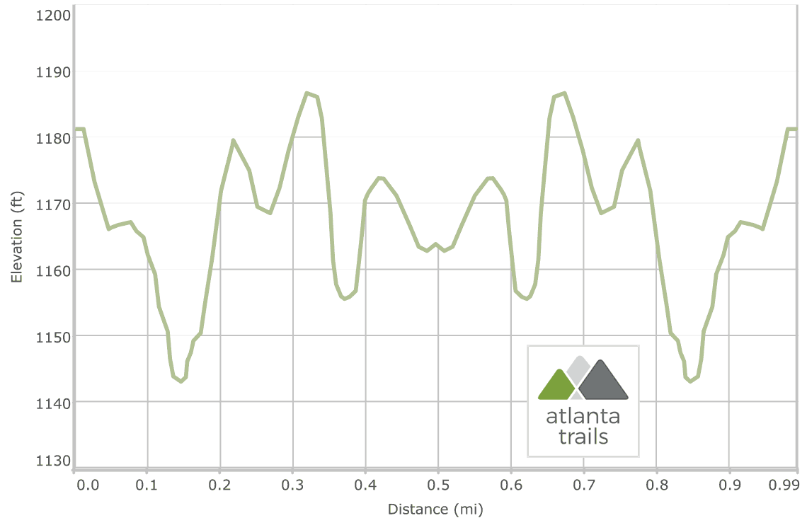
The adventure begins at a signed trailhead at the Ridgeway Recreation Area at Carters Lake (view maps and driving directions), descending elevation into a shady forest. Lush ferns border the trail’s sides and leafy hardwood trees tower overhead as the trail descends. Several old-growth trees flank the trail, with broad trunks dwarfing the surrounding trees as they climb high into the forest canopy.
The trail begins following a small, trickling creek at .15 mile, rolling elevation in a gentle climb to a grassy meadow. The hike passes the field, continuing its moderate ascent. The sound of falling water becomes audible along the trail as the route approaches the first of several waterfalls.

The trail reaches a towering wooden bridge at .35 miles, crossing the 30-foot-tall bridge. To the right, Tails Creek rushes below in a series of small waterfalls, and to the left, the creek widens as it flows into Carters Lake.
After crossing the bridge, the trail treks through a grassy clearing before veering right at .4 mile, hiking northeast. The trail dives back into the shade of the forest, trailing through a deep-cut channel beneath a grove of fresh scented pine. A side trail departs right, hiking to a flat on the banks of the creek. Tails Creek makes a long, sloped spill into a pool of water framed by angular, moss-covered rocks, creating a beautiful waterfall.

From the middle waterfall, the hike continues its northeast-bound trek. At .5 mile, the hike reaches an observation deck, a great vantage point for viewing the upper falls on Tails Creek. The waterfalls here are small, but scenic, as they spill over a stair-stepped series of rock outcrops before pooling above the middle falls downstream.

The hike departs the observation deck and retraces its outbound steps on the Tumbling Waters Nature Trail, making another crossing over the wooden span bridge and trailing through the shady forest. The hike reaches the trailhead at 1 mile, completing the adventure.

Please Remember
Always leave no trace, pack out everything you pack in, and if you see trash, pick it up and pack it out.
Stay on the marked trail, tell someone where you're going, pack safety and wayfinding essentials, and don't rely on a mobile phone to find your way. Please always practice good trail etiquette. And before you go, always check the trailhead kiosk, official maps, and the park or ranger office for notices of changed routes, trail closures, safety information, and restrictions.
Carters Lake Tumbling Waters Nature Trail Map, Directions & Details

Love the trail?
This trail is maintained thanks to the hard work of countless volunteers and donations from supporters of the Chattahoochee National Forest. Please support them by making a donation or joining a volunteer day. Let's work together to keep these fantastic trails maintained and open for use!
Driving Directions
Parking
$4 (daily), or included with a Carters Lake Annual Parking Pass.
GPS Coordinates
34.650267, -84.608983 // N34 39.016 W84 36.539
Elevation Profile