


Hike the Marble Mine Trail in Georgia’s James H “Sloppy” Floyd State Park to an abandoned mine entrance, a trickling waterfall, and beautiful sunset views over a glassy lake.
(round trip)
moderate
friendly
LOCATION:James H Sloppy Floyd State Park near Dalton, Georgia
PACK:our Osprey day pack and our hiking gear list
Rising high from the surrounding forest, an enormous, arched rock outcrop drips a steady, narrow, single-stream waterfall from its towering crest. In front, a still, cool-blue pool collects the waterfall’s continuous drip, reflecting the massive, carved cave above. This stunning sight is the final destination on the Marble Mine Trail, a less-than-two-mile roundtrip hike at Georgia’s James H “Sloppy” Floyd State Park just south of Cloudland Canyon.

This adventure explores a large, abandoned mine entrance on a relatively easy hike. It’s a scenic adventure, departing from the park’s beautiful lakeshore and rising gently through a leafy forest. And it’s a great adventure for families with kids, too: the mine’s cool factor combines with the trail’s relatively short distance and easy effort, making it a great beginner-friendly hike.

Marble Mine Trail: the hike
The adventure begins at the parking area at the park’s picnic shelters, located across the lake from the James H Sloppy Floyd State Park State Park office (view maps and driving directions). If you’re up for a bit of extra distance, hike across the boardwalk to the trailhead from the park office, catching beautiful lakeside views to start the hike.
The lake is especially beautiful in the fall, as vibrant autumn leaf color reflects in the glassy lake surface.

The hike follows orange trail blazes from the trailhead, venturing along a wide gravel roadbed for much of its length. A canopy of young hardwood trees frame the sides of the trail, casting dappled patterns of sunlight and shadow on the forest floor. Scattered white marble fragments litter the trail, evidence of the area’s mining history.
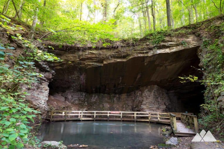
The trail climbs gently, passing several abandoned, vine-covered mining buildings, now in ruins. The hike reaches the mine’s entrance at just under one mile. A large cavern cuts deep into the massive, exposed rock outcrop, creating a dramatically arching cave. Deep depressions dive deep into the hillside on each side of the mine, and a wooden boardwalk extends below the large rock overhang, providing a partial view into the caves. A stream trickles overhead, tumbling 35 feet into the placid blue pool beneath the mine entrance.
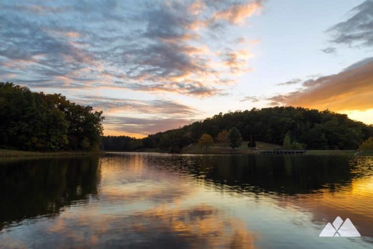
After exploring the mine, the route flips in reverse, retracing its outbound to return to the trailhead and parking area at just under two miles. At the trailhead, explore the lakeshore to catch the reflections of the surrounding forest in the lake’s glassy waters. Sunsets at the park are simply beautiful. As the sun dips towards the horizon, the sunset’s array of color reflects on the smooth water of the lake below.

More adventures near James H Sloppy Floyd State Park
Up for another adventure? Some of North Georgia’s best views and most beautiful waterfalls are a short 45-minute drive north at Cloudland Canyon State Park. Hike to stunning views into the deep-cut gorge on the Cloudland Canyon West Rim Loop, or explore a stunning duo of tumbling falls on the Cloudland Canyon Waterfalls Trail. And explore the stunning landscapes and two incredible waterfalls at Lula Lake Land Trust.
Note: slippery rocks and fast-moving water can be extremely dangerous! Please don’t climb, stand on, swim near, or jump from any waterfall.

Please Remember
Always leave no trace, pack out everything you pack in, and if you see trash, pick it up and pack it out.
Stay on the marked trail, tell someone where you're going, pack safety and wayfinding essentials, and don't rely on a mobile phone to find your way. Please always practice good trail etiquette. And before you go, always check the trailhead kiosk, official maps, and the park or ranger office for notices of changed routes, trail closures, safety information, and restrictions.
Marble Mine Trail Map, Directions & Details

Love the trail?
This trail is maintained thanks to the hard work of countless volunteers and donations from supporters of the Friends of Georgia State Parks. Please support them by making a donation or joining a volunteer day. Let's work together to keep these fantastic trails maintained and open for use!
Driving Directions
Parking
$5
GPS Coordinates
34.438917, -85.335017 // N 34 26.335, W85 20.101
Elevation Profile


