Hike the Angel Falls Trail at North Georgia’s Lake Rabun Beach campground to two beautiful waterfalls, Angel Falls and Panther Falls.
(round trip)
moderate
friendly
LOCATION:Rabun County, east of Hiawassee, Georgia
PACK:our Osprey day pack and our hiking gear list
OFFICIAL MAP: Nat Geo 778 Trails Illustrated Map (find it at Trailful Outdoor Co.)
Near the historic lakeside town of Lakemont, the Angel Falls Trail explores two tumbling waterfalls, Panther Falls and Angel Falls, in a beautiful creek valley. Hiking less than two miles, round trip, the trail is a fantastic family-friendly hike for campers at the Lake Rabun Beach Campground, and worthy of a visit for anyone exploring the namesake lake of Rabun County.

Nestled deep in rolling mountains, Lake Rabun’s winding shoreline and glassy waters are a favorite North Georgia destination for hiking, boating, kayaking, and camping. Just below the lake’s dam, the Tallulah River plummets in a series of enormous waterfalls deep in the steep-walled depths of Tallulah Gorge.

Angel Falls Trail: the hike
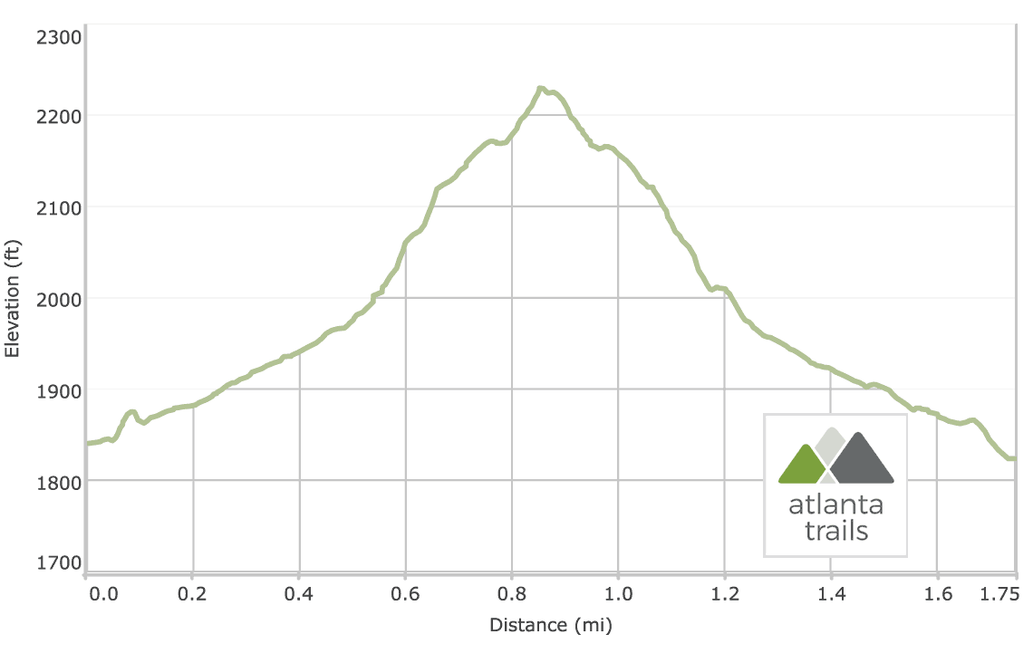
The adventure begins at a trailhead in Loop 2 of the Lake Rabun Beach Campground (view maps and driving directions). The trail follows Joe Creek upstream, crossing a wooden bridge and catching sight of a small, multi-tiered waterfall near the trailhead. The hike ascends stone stairs, climbing elevation into a sun-dappled forest filled with fern, rhododendron and mountain laurel.
The hike continues to ascend, with Joe Creek tumbling over a rocky creek bed on the trail’s right side. The hike reaches a historic, moss-covered stone bench at .3 mile, built by the Civilian Conservation Corps at the site of a small spring in the early 20th century. Now diverted, the spring once flowed through the stone channel below the bench, a source of water for the nearby CCC camp.

The trail passes a large, rocky, mossy outcrop on the right before crossing two bridges, and the sound of tumbling water grows louder. The trail reaches Panther Falls at just under .6 mile, where Joe Creek cascades down a stair-stepped rock outcrop into a tranquil pool of water below.
Departing Panther Falls, the hike hangs a right, climbing the trail’s steepest stretch through a sharp switchback. (Metal cables serve as a safety railing on this stretch of the trail; take extra caution with dogs and children.) The hike climbs, reaching a trail loop; a turn in either direction leads to Angel Falls.

The trail reaches this hike’s second waterfall at .9 miles, catching views of Angel Falls from a wooden platform. Above, the waterfall cascades down over an angled, multi-tiered rock face framed in leafy rhododendron.
Departing the waterfall, the hike retraces its outbound steps to the trailhead. The hike reaches the trailhead at the Rabun Beach Campground at 1.75 miles, finishing the adventure.
Note: slippery rocks and fast moving water can be extremely dangerous! Please don’t climb, stand on, swim near, or jump from any waterfall.

Nearby waterfall adventures
In the area and up for some more waterfall-chasing adventures? Don’t miss the nearby Minnehaha Falls just north on the Lake Rabun shore, a shorter hike to a much larger waterfall. And further north, a beautiful waterfall cascades down into a shady creek valley near the shores of Lake Burton, reached by a popular 2-mile hike on the Hemlock Falls Trail.

Please Remember
Always leave no trace, pack out everything you pack in, and if you see trash, pick it up and pack it out.
Stay on the marked trail, tell someone where you're going, pack safety and wayfinding essentials, and don't rely on a mobile phone to find your way. Please always practice good trail etiquette. And before you go, always check the trailhead kiosk, official maps, and the park or ranger office for notices of changed routes, trail closures, safety information, and restrictions.
Angel Falls Trail at Lake Rabun Map, Directions & Details

Love the trail?
This trail is maintained thanks to the hard work of countless volunteers and donations from supporters of the Chattahoochee National Forest. Please support them by making a donation or joining a volunteer day. Let's work together to keep these fantastic trails maintained and open for use!
Driving Directions
Parking
$4 (daily). Camping at the Lake Rabun Beach campground? Walk to the trailhead and save the parking fee.
GPS Coordinates
34.761333, -83.472700 // N34 45.680 W83 28.362
Elevation Profile