


Rabun County is nestled in Georgia’s northeast corner – and it’s full of opportunities for outdoor adventures. With a trio of gorgeous lakes, towering mountains (including Georgia’s second tallest peak), crystal-clear rivers and tumbling whitewater, there’s a whole lot of hiking, running, biking, rafting and paddling fun to be had in the county. Rabun County’s tumbling waterfalls, 360-degree panoramas from bald mountaintops and wildflower-filled valleys offer some pretty spectacular hiking – and with a high elevation, the county’s weather in summer is usually mild, making it perfect for summertime trail time. Two famous long-range trails, the Appalachian Trail and Bartram Trail, cross through Rabun County, offering fantastic overnight backpacking adventures.
Lake Burton, Lake Rabun and Lake Seed, Rabun County’s trio of beautiful lakes, are a major draw for boaters and paddlers. The glassy lakes, framed by a meandering shoreline bordered in rolling mountains, are exceptionally beautiful, and several waterfalls, Angel Falls, Minnehaha Falls and Hemlock Falls, tumble down near the lakes’ shores.
To the west of the lakes, Tallulah Gorge carves deep into the county, offering hikes with stunning overlook views and adventures to the waterfalls deep within the canyon. East of Clayton, the Bartram Trail explores the banks of the nearly-crystal-clear Chattooga River upstream from its famous, tumultuous whitewater, and winds through Warwoman Dell, a beautiful valley filled with waterfalls and wildflowers. To the north, near Sky Valley, the Bartram Trail hikes to the summit of Rabun Bald, catching take-your-breath-away panoramas from Georgia’s second-tallest mountain. And speaking of mountains, Black Rock Mountain State Park is a lofty, high-elevation adventure with miles of great trails and some stunning views (Black Rock Mountain is Georgia’s highest-elevation state park).

Rabun County hiking trails: our favorite hikes
From north to south and east to west, Rabun County’s beauty is simply stunning. It’s rugged yet serene, from deep-cut canyons with rushing waterfalls to crystalline rivers and placid lakes. It’s easily one of our favorite destinations for outdoor adventure in Georgia. This is our collection of our favorite trails in Rabun County, all worthy of a visit. Hike them all, if you can… you’ll be left in amazement, as we always are, for the immense beauty of this North Georgia county.


STUNNING SKY VALLEY VIEWS
Rabun Bald on the Bartram Trail
3 MILES
The views from Rabun Bald’s summit, the second highest in Georgia, are incredible, 360-degree panoramas that are easily some of the best in all of Georgia. Hike the Bartram Trail from Beegum Gap near Sky Valley to the summit, and soak in the see-forever views from Rabun Bald’s summit platform.
VIEW TRAIL INFO & MAPS
CHATTOOGA RIVER NEAR CLAYTON
Chattooga River Trail and Bartram Trail
5.5 MILES
Upriver from its famous, wild whitewater, the Chattooga River runs mild, scenic and nearly crystal clear over a colorful, pebbled stream bed. Hike the Bartram Trail from Russell Bridge to Adeline Ford, a sandy beach on the Chattooga’s banks.
VIEW TRAIL INFO & MAPS
BARTRAM TRAIL NEAR CLAYTON
Warwoman Dell to Becky Branch Falls
1.4 MILES
Hike this beautiful valley just east of Clayton to waterfalls, wildflowers and through beautiful North Georgia forest. The Bartram Trail and Warwoman Dell Trail visit Becky Branch Falls and several smaller waterfalls on this relatively easy, family-friendly hike.
VIEW TRAIL INFO & MAPS
TALLULAH GORGE STATE PARK
Tallulah Gorge Sliding Rock Trail
3.4 MILES
The Sliding Rock Trail is one of the most difficult that top our list of Rabun County favorites – but it’s well worth the effort. Score a floor permit to hike this trail, scrambling over steep boulders to reach Bridal Veil Falls deep within Tallulah Gorge’s scenic depths.
VIEW TRAIL INFO & MAPS
TALLULAH GORGE STATE PARK
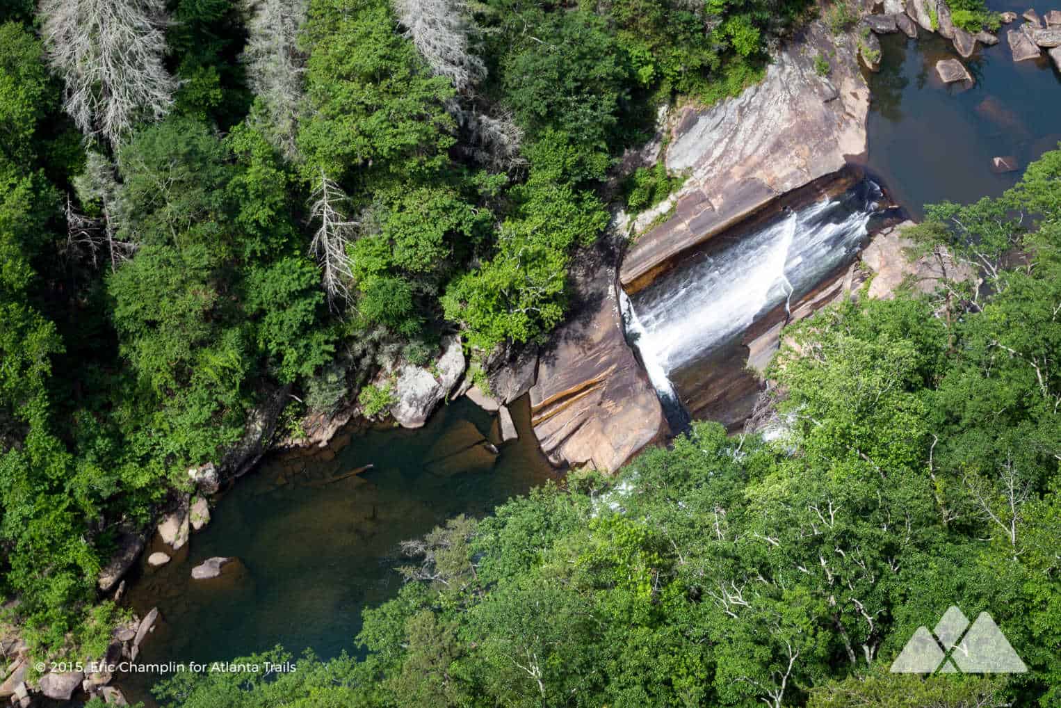
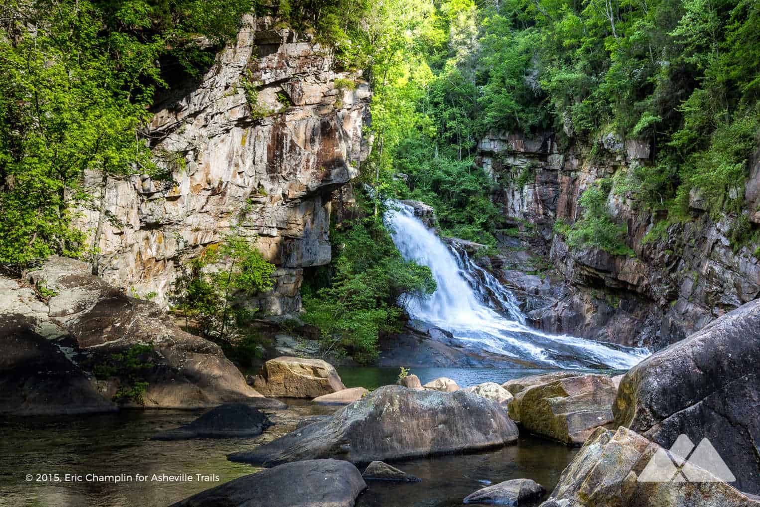
Tallulah Gorge Hurricane Falls Trail
2.25 MILES
Hike the Hurricane Falls Trail, catching outstanding views from the Tallulah Gorge rim before plunging to the gorge floor by stair and a suspension bridge. The hike catches up-close views of the Hurricane Falls waterfall as it thunders through the gorge.
VIEW TRAIL INFO & MAPS

BARTRAM TRAIL
Pinnacle Knob
8.1 MILES
Follow the Bartram Trail from Warwoman Dell, visiting the stunning cascades of Becky Branch Falls and Martin Creek Falls. And from there, the workout begins, following the Bartram Trail and Pinnacle Knob Trail in a steady climb to a nearby summit, where broad rock outcroppings offer beautiful 180-degree views of Black Rock Mountain and into North Carolina.
VIEW TRAIL INFO & MAPS
TALLULAH GORGE STATE PARK
Tallulah Gorge North Rim & South Rim Trails
2.5 MILES
Hike the North Rim Trail and South Rim Trail at Tallulah Gorge State Park for the best views from the towering canyon rim. This two-trail-duo is a fairly easy hike to unforgettable views of the steep-walled gorge and the tumbling, thundering waterfalls deep within the gorge’s depths.
VIEW TRAIL INFO & MAPS
LAKE BURTON WATERFALLS
Hiking the Hemlock Falls Trail at Lake Burton
2 MILES
This Lake Burton hike trails through a beautiful, stream-filled valley to the tumbling cascades of the Hemlock Falls waterfall. This family-friendly hike follows Moccasin Creek upstream from Lake Burton’s shore, visiting the tumbling waterfall as it pours over a sheer cliff in a shady forest.
VIEW TRAIL INFO & MAPS
LAKE RABUN WATERFALLS
Minnehaha Falls
.4 MILE
Easily the easiest and most kid-friendly trail in our list of Rabun County favorites, the Minnehaha Falls trail treks to one of Georgia’s most beautiful waterfalls. Minnehaha Falls cascades from a towering, stair-stepped bluff near the shore of Lake Rabun.
VIEW TRAIL INFO & MAPS
LAKE RABUN WATERFALLS
Angel Falls Trail
1.75 MILES
Hike to two beautiful Rabun County waterfalls on this sub-2-mile trail. The Angel Falls Trail departs from the campground at Lake Rabun Beach, trailing streamside through a shady forest to Angel Falls and Panther Falls.
VIEW TRAIL INFO & MAPS
BLACK ROCK MOUNTAIN STATE PARK
Tennessee Rock Trail at Black Rock Mountain
2.2 MILES
Hike the Tennessee Rock Trail at Black Rock Mountain State Park in northern Rabun County. You’ll score stunning views from the Tennessee Rock Overlook after trailing through a shady forest that’s filled with wildflowers in late spring.
VIEW TRAIL INFO & MAPS
BLACK ROCK MOUNTAIN STATE PARK
Edmond Backcountry Trail at Black Rock Mountain
6 MILES
Hike Georgia’s highest elevation state park at Black Rock Mountain, exploring the mountain’s beauty on the difficult Edmonds Backcountry Trail. This challenging hike climbs multiple mountain summits and visits a remote waterfall near the park’s lake.
VIEW TRAIL INFO & MAPS
APPALACHIAN TRAIL
Appalachian Trail: Dicks Creek Gap to Powell Mountain
5.2 MILES
Hike the Appalachian Trail south from Dicks Creek Gap, trailing through beautiful forest to the summit of Powell Mountain. The summit views are stunning, catching sight of Lake Burton nestled between rolling mountains near the horizon.
VIEW TRAIL INFO & MAPS
APPALACHIAN TRAIL
Appalachian Trail: Dicks Creek Gap to Bly Gap
17.4 MILES
Hike the northernmost stretch of the Appalachian Trail in Georgia, rolling elevation from Bly Gap on the Rabun County border. The trail treks to a gnarled, old oak near the North Carolina state line, and makes a great overnight backpacking adventure.
VIEW TRAIL INFO & MAPS
BACKPACKING ADVENTURE
Bartram Trail
35 – 70 MILES
Follow the footsteps of the 18th century explorer and botanist William Bartram through Rabun County on this epic backpacking journey. The route climbs to stunning views at Rabun Bald, visits the tumbling waterfalls on Martin Creek and Becky Branch, explores the lush valley at Warwoman Dell, and follows the banks of the Chattooga River to the GA/SC state line.
VIEW TRAIL INFO & MAPS
What to pack?
Our favorite hiking gear
Ready to hit the trail, but wondering what to pack? Our hiking gear list features our favorite, trail-tested hiking gear for day hikes on local trails and in the Georgia backcountry. We print and stitch our Atlanta Trails shirts and hats locally in Atlanta and Asheville, and they’re our favorite for trail adventures all over the South. Please leave no trace and help preserve Georgia’s beauty.
OUR HIKING GEAR LIST


Please Remember
Always leave no trace, pack out everything you pack in, and if you see trash, pick it up and pack it out.
Stay on the marked trail, tell someone where you're going, pack safety and wayfinding essentials, and don't rely on a mobile phone to find your way. Please always practice good trail etiquette. And before you go, always check the trailhead kiosk, official maps, and the park or ranger office for notices of changed routes, trail closures, safety information, and restrictions.


