


Hike a seven-mile day hike on the Appalachian Trail in Georgia, exploring a lush, green, leafy forest from Hightower Gap to Horse Gap, over Sassafrass Mountain and down to Cooper Gap.
(round trip)
difficult
friendly
LOCATION:Appalachian Trail near Blue Ridge, Georgia
PACK:our Osprey day pack and our hiking gear list
OFFICIAL MAP: Appalachian Trail, Trails Illustrated Map (find it at Trailful Outdoor Co.)
This Georgia Appalachian Trail segment doesn’t climb to a stunning, wide, take-your-breath-away summit view. Nor does it visit a waterfall (or any semblance of running water for that matter). And it’s not exceptionally difficult, either: this AT segment rolls fairly gently over several small knobs and through several gaps before climbing to the top of Sassafrass Mountain and dipping down to Cooper Gap, a moderately difficult hike.
Okay, so why bother? While this stretch of the AT from Hightower Gap to Cooper Gap isn’t especially noteworthy, it does explore a bunch of classically beautiful North Georgia forest. Flowering trees and wildflowers dot the trail’s sides in warmer months, and breaks in the trail’s dense tree cover offer limited views of nearby rolling Appalachians. It’s a great day hike or trail run, and an equally great extension to a hike on the Appalachian Trail from Three Forks to the Hawk Mountain Shelter. And, of course, it’s a must-hike for AT thru-hikers on their epic journey from Springer Mountain to Maine.

There not a single trickle of creek or stream on this stretch of the trail. While the trail is mostly shaded by tree cover in summer, this stretch is one of the lowest-elevation sections of the AT in Georgia – so, unlike loftier sections like Blood Mountain, Tray Mountain or Rocky Mountain, this section of trail often sees some scorching weather in the summer. So be sure to pack plenty of water – or if you’re backpacking through, filter and fill at the Gooch Mountain Shelter or Hawk Mountain Shelter before hitting this stretch.

Hightower Gap to Cooper Gap: the hike
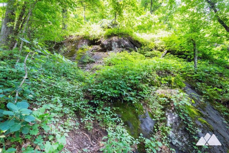
The adventure begins at the intersection of the Appalachian Trail and two gravel roads (FS69 and FS42) at Hightower Gap (view maps and driving directions), following the AT’s white rectangular trail blazes eastbound. The hike climbs from the gap, passing several campsites in the first third of a mile. The forest is shady, occasionally rocky, and abundantly green, and vines climb to the forest canopy, clinging to trees as they chase sunlight. A side trail departs the AT at .4 mile, hiking to a rocky outcrop with limited, through-the-trees views.

Leaving the overlook, the trail rolls elevation, passing a third campsite at .8 mile and a large, old-growth oak at 1.5 miles. The trail begins a sharp descent, crossing through Horse Gap at 1.8 miles. The hike climbs from Horse Gap, starting a nearly unrelenting climb of Sassafrass Mountain in the next mile. The hike passes several towering rock outcrops as it winds through sharp switchbacks.
The hike passes two campsites near the Sassafrass Mountain summit. The summit is densely tree-covered, and the warm-weather views are disappointingly non-existent in this leafy hardwood forest.

And onward to Cooper Gap
Departing Sassafrass, the hike descends 440 feet over the next mile to Cooper Gap. The trail hits Cooper Gap at 3.4 miles, reaching the FS42 gravel road. From here, the AT continues an eastbound trek, rolling over Justis Mountain to the Gooch Mountain Shelter, 3.2 miles from Cooper Gap. This hike turns, retracing its outbound steps to reach Hightower Gap at 6.8 miles, completing the adventure.

Please Remember
Always leave no trace, pack out everything you pack in, and if you see trash, pick it up and pack it out.
Stay on the marked trail, tell someone where you're going, pack safety and wayfinding essentials, and don't rely on a mobile phone to find your way. Please always practice good trail etiquette. And before you go, always check the trailhead kiosk, official maps, and the park or ranger office for notices of changed routes, trail closures, safety information, and restrictions.
Appalachian Trail Hightower Gap to Cooper Gap Map, Directions & Details

Love the trail?
This trail is maintained thanks to the hard work of countless volunteers and donations from supporters of the Georgia Appalachian Trail Club. Please support them by making a donation or joining a volunteer day. Let's work together to keep these fantastic trails maintained and open for use!
Driving Directions
Parking
Free. The USFS Hightower Gap trailhead is accessed via gravel Forest Service roads.
GPS Coordinates
34.663650, -84.129667 // N34 39.819 W84 07.780
Elevation Profile


