Hike the Appalachian Trail southbound from Woody Gap to beautiful views at Ramrock Mountain, campsites at Gooch Gap, and the Gooch Mountain Shelter, exploring a lush, rocky forest.
(round trip)
difficult
friendly
LOCATION:Appalachian Trail near Dahlonega, Georgia
PACK:our Osprey day pack and our hiking gear list
OFFICIAL MAP: Appalachian Trail, Trails Illustrated Map (find it at Trailful Outdoor Co.)
Three stunning views, fantastic campsites, and a whole lot of classic, lush southern Appalachian forest: this is one great day hike or overnight backpacking adventure on the Appalachian Trail in Georgia. It’s a well-loved trek, popular for its stunning summit views, starting with exceptional views from Woody Gap at the trailhead. Hiking south on the AT from Woody Gap, the hike scores stunning views at a pair of overlooks on Ramrock Mountain, and explores an old growth forest near Gooch Gap before reaching the Gooch Mountain Shelter.

Woody Gap, located on the Appalachian Trail north of Dahlonega and just south of Suches, is one of Georgia’s most popular AT trailheads. With parking on both sides of the paved highway (view maps and driving directions), Woody Gap offers hikers and backpackers easy access to the AT. From the gap, the Appalachian Trail hikes north to beautiful views at Big Cedar Mountain before trailing northeast to Jarrard Gap and Blood Mountain. This hike walks southbound from the gap, and while it’s slightly lesser traveled than the northbound route to Preachers Rock, it rewards with some stunning views and a bit of trail serenity.

Appalachian Trail south from Woody Gap: the hike
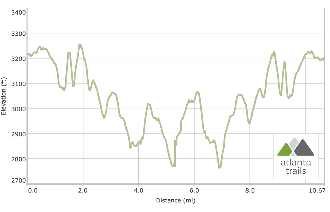
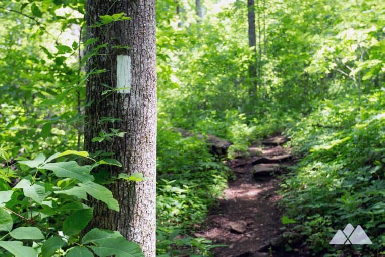
The adventure begins at Woody Gap (view maps and directions), hiking southbound. The hike follows the iconic white blazes of the Appalachian Trail, rolling elevation and trailing southwest, skirting the summit of Black Mountain. The hike winds through a rocky, ferny, outcrop and boulder-filled forest, catching through-the-trees views on the trail’s left side.
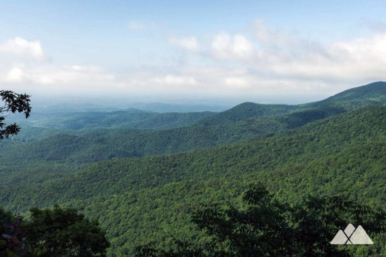
The trail descends elevation, departing Black Mountain and leaving the highway sounds at Woody Gap behind. The hike levels briefly at 1.3 miles before beginning a steady climb, ascending Ramrock Mountain and climbing over boulders and rough-hewn stone stairs. The Appalachian Trail reaches the Ramrock Mountain summit at 1.5 miles, catching stunning views from a broad rock outcrop at the summit.
North of the Ramrock Mountain overlook, there’s a just-off-trail campsite with a stone fire ring. It’s is one of our favorite campsites on the Appalachian Trail in Georgia, offering stunning sunrise views on clear mornings. (Our other favorite? The summit campsite at Wolf Laurel Top north of Neel Gap and Blood Mountain.)
Departing the summit, the trail descends, plunging through Jacks Gap. The hike reaches Jacks Gap at 1.65 miles, and then makes a short climb. The hike reaches a second rocky overlook with outstanding views at 1.9 miles, and a campsite lies nearby.
Departs Ramrock Mountain, the trail arcs to the southwest, rolling elevation under a dense canopy of mountain laurel. The forest is rich and vibrantly green, filled with trailing ivy, ferns and seasonal wildflowers.

Gooch Gap Campsites
The hike reaches Gooch Gap at 3.7 miles. Camping options at Gooch Gap are plentiful, with campsites flanking both sides of the trail over a quarter mile stretch. A blue-blazed side trail leads a short distance south from the gap to a water source, Walden Creek.
Departing Gooch Gap, the Appalachian Trail crosses a gravel road, Cooper Gap Road. The hike crosses a stream at 4 miles before climbing elevation through an old-growth forest of broad-trunked oak and tulip trees. The hike descends, passing a campsite at 4.8 miles before diving through a grove of young, spindly-trunked trees.
Gooch Mountain Shelter
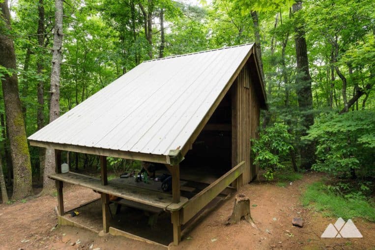
A blue-blazed side trail departs the AT at 5.2 miles, hiking northwest toward the Gooch Mountain Shelter and campsites. The tin-roofed Gooch Mountain Shelter was constructed in 2001, and is one of the newest AT shelters on the trail’s 2000+ mile stretch from Georgia to Maine.
Campsites are located west of the shelter, accessible by a short, diverging trail. Two trails depart north from the shelter, one to a water source and the other to a privy.
Departing the Gooch Mountain shelter, this hike turns to retrace its outbound route on the AT, trekking through Gooch Gap, climbing Ramrock Mountain skirting the peak of Black Mountain. The hike reaches the Woody Gap trailhead at 10.8 miles, completing the adventure.

Please Remember
Always leave no trace, pack out everything you pack in, and if you see trash, pick it up and pack it out.
Stay on the marked trail, tell someone where you're going, pack safety and wayfinding essentials, and don't rely on a mobile phone to find your way. Please always practice good trail etiquette. And before you go, always check the trailhead kiosk, official maps, and the park or ranger office for notices of changed routes, trail closures, safety information, and restrictions.
Woody Gap to Ramrock Mountain and Gooch Mountain Map, Directions & Details

Love the trail?
This trail is maintained thanks to the hard work of countless volunteers and donations from supporters of the Georgia Appalachian Trail Club. Please support them by making a donation or joining a volunteer day. Let's work together to keep these fantastic trails maintained and open for use!
Driving Directions
Parking
Free parking is available at the Woody Gap trailhead.
GPS Coordinates
34.677333, -84.000117 // N34 40.640 W84 00.007
Elevation Profile