Hike Cloudland Canyon’s Waterfalls Trail, East Rim Loop Trail and Overlook Trail for beautiful wintertime views, icicle-covered canyon walls and frosty, icy waterfalls.
(round trip)
difficult
for dogs
LOCATION:Cloudland Canyon State Park near Dalton, Georgia
PACK:our Osprey day pack and our hiking gear list
Cloudland Canyon State Park is packed with natural beauty that’s visit-worthy year-round: steep canyon walls frame a deep-cut gorge that’s filled with massive boulders, lofty rock outcrops and towering, tumbling waterfalls. And while the cooler months lack springtime’s wildflowers or autumn’s colorful leaf displays, the park transforms into an incredible destination for winter hiking in Georgia.

The canyon’s towering hemlock tree canopy stays evergreen in the winter, long after the surrounding deciduous trees have dropped their leaves – and the lack of leaves on trees opens wider views than in other seasons. And when temperatures drop below freezing, Cloudland’s waterfalls freeze in a frosty display framed by icicles hanging from the sheer canyon walls. Wintertime seems to accentuate Cloudland Canyon’s beauty, scoring it high on our favorite Winter hikes in Georgia.

Cloudland Canyon in winter: the hike
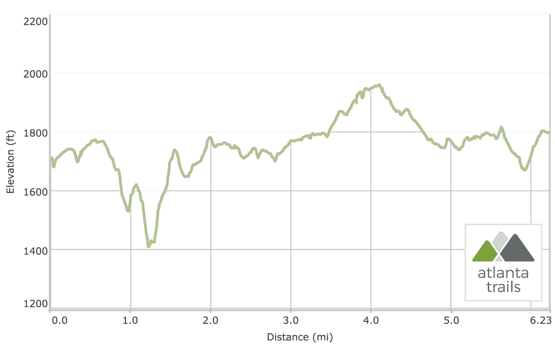
This hike spans just over six miles, catching most of our favorite views in the park. The hike begins on the Overlook Trail on Cloudland’s East Rim (view maps and driving directions), starting at the overlook near picnic shelter #4. The hike catches its first glimpse into the canyon’s eastern edge before trailing northbound on the paved Overlook Trail, reaching the Main Overlook at .3 mile. The hike turns right to descend to the Main Overlook, catching stunning, wide views into the steep-walled canyon below.
Departing the Main Overlook, the Overlook Trail continues to trace the canyon’s East Rim, catching additional views into the canyon’s depths as it treks southwest. The hike leaves pavement at .6 mile, following the unpaved Waterfalls Trail in a descent into the canyon. The hike follows signs to Cherokee Falls, passing an enormous rounded rock outcrop and alternating between unpaved trail, metal stairs and wooden boardwalks in a sharp descent into the canyon. The hike meets Cherokee Falls (first photo above) at 1 mile, scrambling over boulders littering the canyon’s floor for a view of the waterfall. When temperatures drop below freezing, icicles and frost cling to the waterfall’s enormous, arced outcrop, creating a beautiful backdrop to the falls.
Departing Cherokee Falls, the hike retraces to the Waterfalls Trail, descending further into the canyon’s depths via stairs. The hike reaches the park’s second epic waterfall, Hemlock Falls, at 1.25 miles, catching views of the frosty falls from a wooden viewing platform.

Departing Hemlock Falls, the hike ascends to the East Rim, retracing its outbound steps via metal stairs in a difficult, 600-stair climb to the rim. The hike reaches the West Rim Loop trailhead at 1.55 miles, turning right to descend a short stretch of stairs before crossing a wooden bridge spanning Sitton’s Gulch Creek at 1.7 miles.
The hike trails under evergreen hemlock, passing a cave and the park’s yurt campground before catching its first views from the West Rim on a large, open rock outcrop at 2.3 miles. The West Rim Loop Trail crosses a wooden bridge at 2.6 miles before turning right to hike the loop trail counterclockwise. The trail catches views from overlooks at 2.8 miles and 3.25 miles – our favorite vistas at Cloudland Canyon for their broad, sweeping panoramas of the colorful, steep-sloped walls across the canyon.

The West Rim Loop Trail ascends elevation, catching one last set of breathtaking views from an overlook at 3.9 miles before swinging southbound. The hike passes through a field of giant boulders before crossing a paved road, hiking south through a young forest. The trail crosses a small stream via stepping stones at 4.7 miles before reaching the trail’s wooden bridge at 4.9 miles, completing the loop portion of the hike. From here, the hike retraces its steps to the East Rim trailhead, completing the hike at just over 6.2 miles.

Cloudland Canyon: winter hiking safety
While winter adds beauty to Cloudland Canyon’s landscapes, it also adds a need for care and safety. Watch for falling ice and rock from the canyon walls, and watch your step: ice-covered surfaces can be slippery. Slippery rocks and fast moving water can be extremely dangerous! Do not climb, stand above, swim near, or jump from any waterfall. See more water safety tips. And as always, pack plenty of water and first aid supplies (check out our hiking gear list for our favorite, trail-tested gear), and wear a quality hiking boot for good grip on rocky terrain.

Please Remember
Always leave no trace, pack out everything you pack in, and if you see trash, pick it up and pack it out.
Stay on the marked trail, tell someone where you're going, pack safety and wayfinding essentials, and don't rely on a mobile phone to find your way. Please always practice good trail etiquette. And before you go, always check the trailhead kiosk, official maps, and the park or ranger office for notices of changed routes, trail closures, safety information, and restrictions.
Cloudland Canyon Map, Directions & Details

Love the trail?
This trail is maintained thanks to the hard work of countless volunteers and donations from supporters of the Friends of Georgia State Parks. Please support them by making a donation or joining a volunteer day. Let's work together to keep these fantastic trails maintained and open for use!
Driving Directions
Parking
$5
GPS Coordinates
34.833567, -85.477483 // N34 50.014 W85 28.649
Elevation Profile