


Our top Georgia winter hikes explore frozen waterfalls, frosty mountaintops and stunning views in one of our state’s top hiking & backpacking seasons.
Don’t ditch your hiking boots when temperatures plummet and the foliage falls: you’ll miss out on one of Georgia’s best hiking seasons. Autumn’s deciduous leaf drop opens wide winter vistas on mountain summits otherwise cloaked in leaf cover. Icicles drip from the crest of waterfalls, creating light-reflecting prisms. And wintery fog and snow dustings turn familiar, favorite landscapes into new sensory experiences. Welcome to winter hiking in Georgia’s cool climate.
Winter is a great season to break out the tent and head for adventure: cool nighttime temperatures make the season perfect for some snug winter camping or a frosty Georgia backpacking adventure. There’s nothing quite like waking up to a forest blanketed in a newly-fallen layer of snow, or downing a piping-hot cup of coffee at a frosty, icy campsite.

Georgia winter hikes: our top 12 favorite wintertime hikes
These are our favorite Georgia winter hikes, from the chilly altitudes of Georgia’s southern Appalachian mountains to its more temperate southern coastline. They’re all beautiful year-round, but arguably better in cooler temperatures: it’s a great time to hit Georgia’s usually-sweltering southern half, and in the north GA mountains, nothing beats the beauty of a frozen waterfall.


Cumberland Island
2+ miles
Backpack this wild yet serene barrier island off Georgia’s southern coast among Carnegie mansion ruins, wild horses and armadillo. Cumberland’s temperate climate and scarcity of insects in the winter make chillier months a great time to hike this exceptionally beautiful National Seashore.
VIEW TRAIL INFO & MAPS
Hiking Cloudland Canyon in winter
6.2 miles
Hike a three-trail trio at Georgia’s Cloudland Canyon State Park to catch stunning wintertime views, icicle-covered canyon walls and frosty waterfalls. This 6-mile adventure catches stunning views from both of Cloudland’s towering canyon rims, and plunges into the canyon’s depths for up-close views of Cloudland’s stunning, frosty waterfalls.
VIEW TRAIL INFO & MAPS
Arkaquah Trail at Brasstown Bald
11 miles
The Arkaquah Trail decends from the towering Brasstown Bald, Georgia’s highest-elevation mountain summit, on a view-packed ridge line. Though winter winds frequently whip the ridge, the forest’s fallen leaves offer better winter views than other seasons. You’ll visit ancient Native American petroglyph carvings at Track Rock Gap before starting the hike’s winter-worthy workout: a heart-racing climb back to the Brasstown summit.
VIEW TRAIL INFO & MAPS
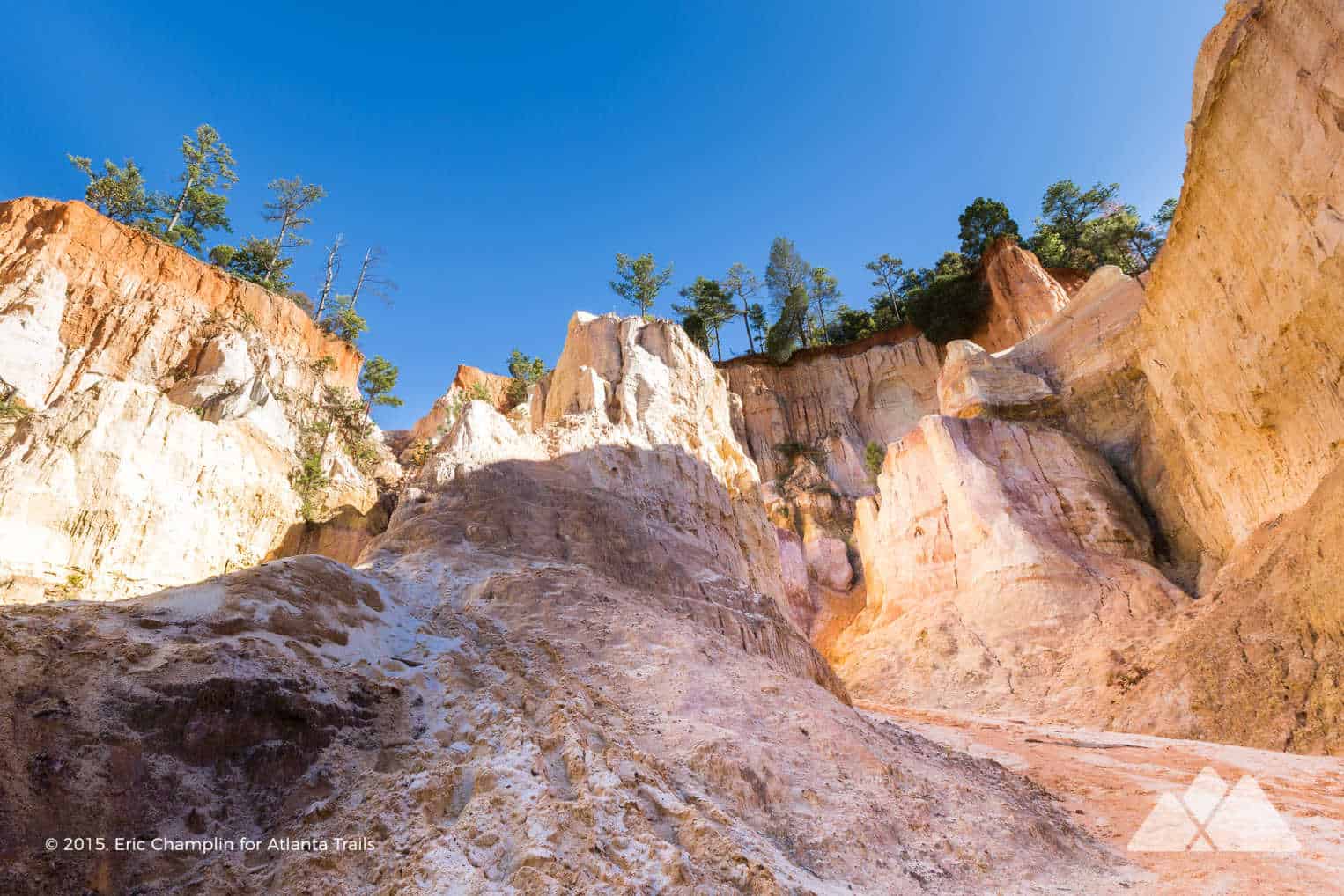
Providence Canyon State Park
4.8 miles
Weave through meandering walls colorful sandstone at Georgia’s “Little Grand Canyon”, Providence Canyon State Park. Set in a forest of pine, the wintertime views at Providence are spectacular, as the evergreen forest contrasts with the sculpted canyon walls in hues of orange, white, pink and deep purple.
VIEW TRAIL INFO & MAPS
Anna Ruby Falls
.9 mile
Hike to the stunning double cascades at Anna Ruby Falls on this paved, stroller-friendly trail near Unicoi State Park. At just under 1 mile, round trip, the trail is an especially beginner-friendly and kid-friendly adventure, and chilly winter mornings at the waterfall dodge the usual crowds.
VIEW TRAIL INFO & MAPS
A.T. Approach Trail
15.6 miles
Hike the Appalachian Approach Trail from the enormous Amicalola Falls waterfall to Springer Mountain, the Appalachian Trail’s southern end, where summit views are sweeping and wide in winter.
VIEW TRAIL INFO & MAPS
Yonah Mountain Trail
4.4 miles
Frost-tipped mountaintops and icy valleys. Icicle-crusted boulders and a fragrant, windswept summit pine. While the hike to Yonah Mountain’s iconic summit is beautiful in any season, it’s especially adventure-worthy in winter – but be especially cautious in icy weather on Yonah’s extremely sudden and extremely steep dropoffs.
VIEW TRAIL INFO & MAPS
Blood Mountain Loop on the Appalachian Trail
6 miles
Hike the Appalachian Trail and two side trails on the Blood Mountain Loop Trail near Helen, Georgia. After catching summit views, the hike grabs solitude on the mountain’s lesser-traveled slope and hikes through a boulder-filled forest.
VIEW TRAIL INFO & MAPS
Jacks River Falls on the Beech Bottom Trail
9 miles
Hike the rugged, remote and wild Cohutta Wilderness in winter to the enormous Jacks River Falls, one of Georgia’s most beautiful waterfalls. The Beech Bottom Trail offers the most direct (and dryest) route to these thundering falls, skipping the Jacks River Trail’s infamous, wet river crossings.
VIEW TRAIL INFO & MAPS
Rabun Bald via the Bartram Trail
3 miles
Hike a segment of the Bartram Trail from Beegum Gap to Georgia’s second-highest elevation mountain. The views from the Rabun Bald summit are simply spectacular, stretching 360 degrees in all directions. Expect chilly mountaintop air in the winter, but be prepared to be wowed by one amazing view.
VIEW TRAIL INFO & MAPS
Sweetwater Creek White Trail
4.1 miles
Hike the White Trail at Sweetwater Creek State Park to visit Civil War-era mill ruins and rugged, whitewater and waterfall-filled terrain. The forest’s moss and fern provide evergreen color in winter – and early wildflowers emerge in February.
VIEW TRAIL INFO & MAPS
What to pack?
Our favorite hiking gear
Ready to hit the trail, but wondering what to pack? Our hiking gear list features our favorite, trail-tested hiking gear for day hikes on local trails and in the Georgia backcountry. We print and stitch our Atlanta Trails shirts and hats locally in Atlanta and Asheville, and they’re our favorite for trail adventures all over the South. And no matter what you pack in, pack it all back out. Please leave no trace and help preserve Georgia’s beauty.
OUR HIKING GEAR LIST


Please Remember
Always leave no trace, pack out everything you pack in, and if you see trash, pick it up and pack it out.
Stay on the marked trail, tell someone where you're going, pack safety and wayfinding essentials, and don't rely on a mobile phone to find your way. Please always practice good trail etiquette. And before you go, always check the trailhead kiosk, official maps, and the park or ranger office for notices of changed routes, trail closures, safety information, and restrictions.


