Hike a strenuous 2.4 miles roundtrip on the Big Mountain Trail, climbing Kennesaw Mountain, the site of a Civil War battle, to breathtaking Atlanta skyline views.
(round trip)
moderate
friendly
LOCATION:Kennesaw Mountain near Atlanta, Georgia
PACK:our Osprey day pack and our hiking gear list
This moderately difficult out-and-back hike summits Kennesaw Mountain, grabbing stunning, extensive views from the mountain’s rocky, open peak. The Kennesaw Mountain Trail climbs a rocky, shaded, steeply-pitched terrain to the summit – a moderately challenging, but relatively short, hike. The summit views make the effort worthwhile, though: from the summit, the Atlanta skyline and Stone Mountain are visible on the distant horizon.
Kennesaw Mountain was the site of a major Civil War battle in the Battle of Atlanta. It’s now both a battlefield memorial and expansive park for outdoor enjoyment, with an extensive network of hiking and running trails. This hike on the Kennesaw Mountain Trail explores the mountain’s natural landscapes, some beautiful views, and historic artifacts. It’s an equally great lesson in Civil War history and a great workout.
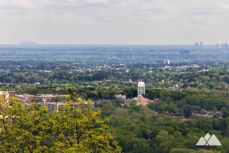 View from the Kennesaw Mountain summit, with the Atlanta skyline and Stone Mountain on the horizon

Kennesaw Mountain Trail: the hike
The Kennesaw Mountain Trail departs the park’s Visitor Center (view maps and driving directions), crossing a paved road to the south before diving into the forest on a dirt trail. The trail quickly begins to rise in elevation, climbing the lower base of Kennesaw Mountain under a deciduous forest canopy. The landscape is rocky, filled with weathered rock fragments and craggy rock outcrops. The trail meanders through a series of switchbacks as it climbs.
The hike meets pavement at .85 mile, nearing the mountain’s summit. After grabbing stunning, long-range views from the parking area, the Kennesaw Mountain Trail climbs a staircase and begins following a paved trail.
A line of cannons line the trail’s right side, nestled within crescent-shaped, mounded earthworks. The large cannons aim to the northeast, pointed in the direction of the encroaching Union army during the battle of Kennesaw Mountain.

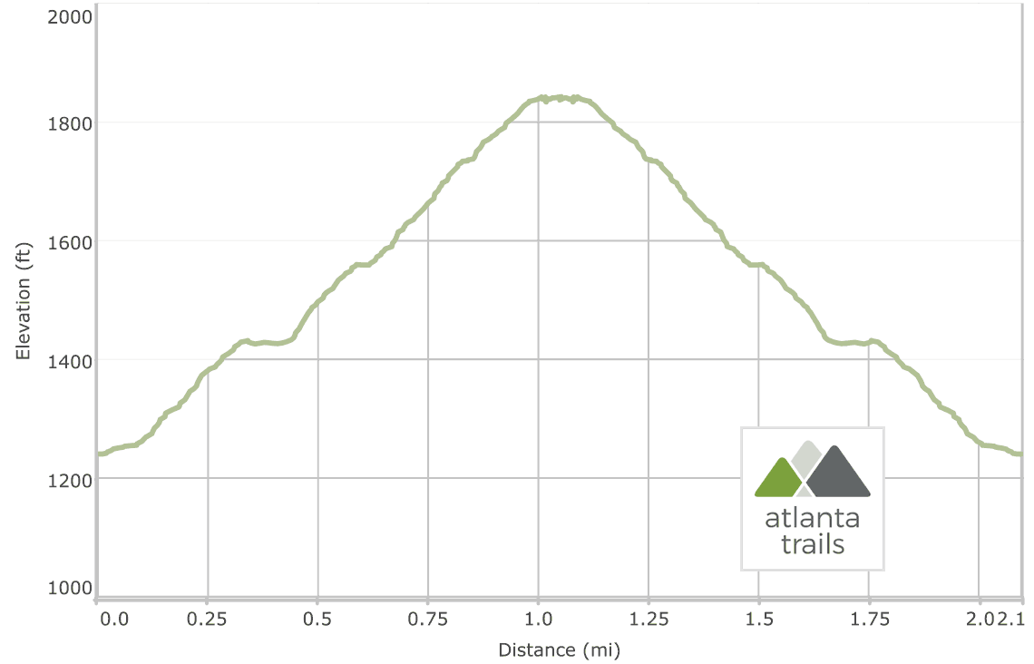
The Kennesaw Mountain Trail continues to climb elevation before cresting the mountain’s summit at just over 1 mile.
Expansive, grooved, exposed rock covers the mountain, offering a resting spot and vantage point for the incredible long-range views. Stunning views extend to the north and south from the summit.

Departing the summit, the hike retraces its outbound steps on the Kennesaw Mountain Trail to the visitors center trailhead. It’s a nearly all downhill return route, a reward for the workout on the climb to the summit. The trail meets the Kennesaw Mountain Visitor Center trailhead at 2.1 miles, completing the hike.

More Kennesaw Mountain hiking & running adventures
Up for some more outdoor adventure at Kennesaw Mountain? Check out our favorite Kennesaw Mountain hiking and running trails to explore the park’s battlefields, beautiful forest, meandering creeks, and wildlife habitats.

Please Remember
Always leave no trace, pack out everything you pack in, and if you see trash, pick it up and pack it out.
Stay on the marked trail, tell someone where you're going, pack safety and wayfinding essentials, and don't rely on a mobile phone to find your way. Please always practice good trail etiquette. And before you go, always check the trailhead kiosk, official maps, and the park or ranger office for notices of changed routes, trail closures, safety information, and restrictions.
Kennesaw Mountain Trail Map, Directions & Details

Love the trail?
This trail is maintained thanks to the hard work of countless volunteers and donations from supporters of the Kennesaw Mountain Trail Club. Please support them by making a donation or joining a volunteer day. Let's work together to keep these fantastic trails maintained and open for use!
Driving Directions
Parking
Beginning November 13, 2019, the National Park Service will be charging a $5 per vehicle entrance fee with a $40 annual pass option at Kennesaw Mountain.
GPS Coordinates
33.982433, -84.578120 // N33 58.946 W84 34.687
Elevation Profile