


Score a gorge floor permit at Tallulah Gorge State Park to hike the spectacular, boulder-filled Sliding Rock Trail, and get an up-close view of the Bridal Veil Falls waterfall deep within the gorge.
(round trip)
difficult
allowed
LOCATION:Tallulah Gorge State Park in Rabun County, Georgia
PACK:our Osprey day pack and our hiking gear list
OFFICIAL MAP: Nat Geo 778 Trails Illustrated Map (find it at Trailful Outdoor Co.)
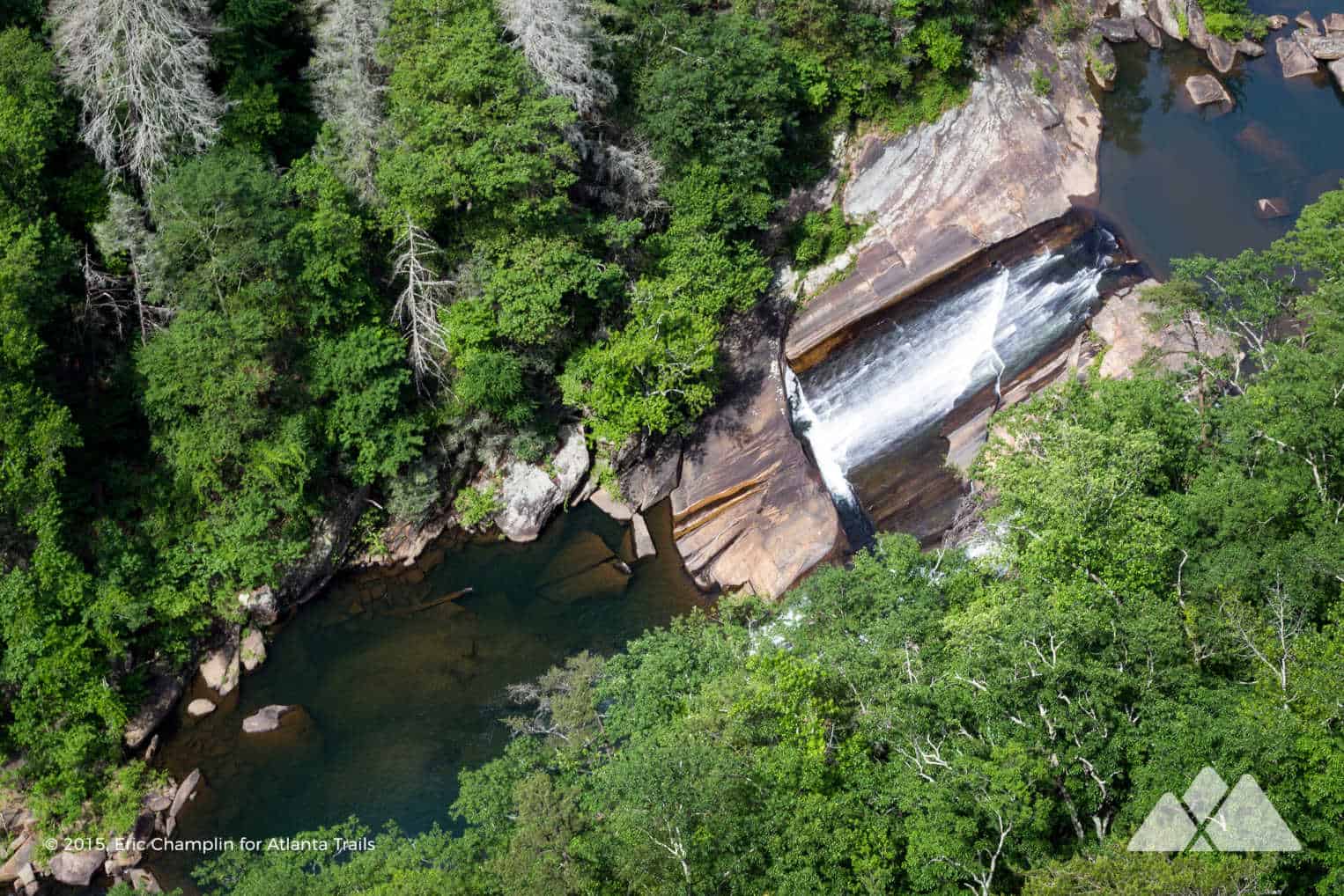
Two miles long. 1000 feet deep. Stunningly beautiful, rugged terrain, sheer walls and tumbling waterfalls: Tallulah Gorge is one of North Georgia’s can’t-miss hiking destinations. But while most hikers trek this park’s open-access trails to waterfalls and whitewater-filled views from dizzying heights, only a lucky few get to hike deep into Tallulah’s depths to remote sections of the gorge floor. The Sliding Rock Trail visits deep, remote sections of the gorge floor that few get to see. It’s a strenuous hike that requires a permit, but it’s worth the workout – and it’s easily one of our all-time favorite adventures in Georgia’s State Parks.

This adventure dives deep into Tallulah Gorge by way of a rocky, boulder-filled trail. This 3.4 mile Tallulah Gorge hike catches stunning views on the Hurricane Falls Loop, descending into the gorge via stairs and an acrophobia-inducing suspension bridge before ascending to the canyon’s south rim. On the south rim, the hike scrambles down the steep, boulder-filled Sliding Rock Trail to the gorge floor, catching an up-close view of the Bridal Veil Falls waterfall.
Scoring a permit to hike the Sliding Rock Trail is rather easy: permits are free but limited to 100 per day, so arrive early on fair-weather weekends. (Apply for a permit in-person at the park’s interpretive center. They’re limited to 100 per day and not available on dam release days; check the park’s schedule for more details. Dogs aren’t allowed on this trail, though, so please leave your four-legged hiking buddies at home.)

Talluah Gorge Sliding Rock Trail: the hike
The hike departs the Tallulah Gorge State Park interpretive center (view maps and driving directions), turning left at the first trail intersection to explore the gorge’s north rim. The hike catches its first views of the steep-walled gorge at overlooks 1A and 1, peering down into the steep-walled depths carved deep by the Tallulah River far below. Departing the toppled Wallenda tower at Overlook 1, the hike treks further eastbound. The trail climbs elevation to Inspiration Point, catching views of the long, whitewater tendrils of Bridal Veil Falls below the overlook.
Departing Inspiration Point, the hike turns westbound, retracing back past overlooks 1 and 1A. The route turns left at 1.1 miles, passing overlooks 2 and 3 and peering deep into the gorge. The hike follows the Hurricane Falls Trail from overlook 2, descending into the gorge by metal stairs and reaching the suspension bridge at 1.25 miles. The bridge sways with every step, suspended high above the whitewater-filled channels of the Tallulah River as it carves deep into the gorge’s rocky floor.
The hike hangs a left after crossing the bridge, descending to the base of the Hurricane Falls waterfall via another stretch of metal stairs. The trail reaches a platform near the waterfall’s base, catching views of the thundering waterfall as it dives into a deep pool framed by scattered boulders.
Your gorge floor permit (*you remembered your permit, right?) allows you to cross the Tallulah River here. If you do, you’ll hike a trail on the river’s north bank to reach Bridal Veil Falls .4 miles downstream. We’re skipping the crossing on this hike, though, opting to climb to Tallulah Gorge’s south rim on the Hurricane Falls Trail and scramble to Bridal Veil Falls on the Sliding Rock Trail. Departing Hurricane Falls, the hike ascends stairs to return to the suspension bridge, veering left at the bridge to climb stairs to the south rim.
Just after passing a wide-trunked, old growth oak tree, the hike ascends its last stair, reaching Tallulah Gorge’s south rim at 1.55 miles. The route turns left, hiking the South Rim Trail eastbound and veering right at 1.6 miles, beginning the hike on the Sliding Rock Trail. The trail crosses a through a power line clearing before reaching the south Wallenda tower at 1.7 miles. Passing the tower, the hike begins a sharp descent over a rocky, boulder-filled trail.

In truth, this isn’t much of a trail. It’s not blazed, and it’s a rocky descent that requires some decent trail spotting to navigate. The trail descends 500 feet over .4 mile, diving deep into remote recesses of Tallulah Gorge. Lizards bask on sun-drenched rocks, scurrying when they sense the approach of oncoming hikers.
The hike reaches the Tallulah Gorge floor at 2 miles. The Tallulah River pools in a deep-cut channel just above Bridal Veil Falls, tumbling downward in white wisps across an angled, open rock outcrop to create the Bridal Veil Falls waterfall.
Just below the falls, the river pools in a deep, turquoise pool framed by the sheer walls of the gorge. It’s a great swimming hole and the only place the park permits swimming within the gorge. Take a cool, refreshing dip in the river and soak up some sunshine before the challenging climb back to the south rim.

Departing the waterfall, the hike returns to the Sliding Rock Trail, scrambling over angular rocks to climb back to the south rim. Reaching the south edge, the hike retraces the South Rim Trail along Tallulah Gorge’s towering rim, catching views into the gorge from overlooks 6 and 7. The route crosses the gorge along Highway 441 near the Tallulah River dam, then travels northbound on the North Rim Trail past overlooks 5, 4 and 3. The North Rim Trail reaches the Tallulah Gorge interpretive center at 3.4 miles, completing the hike.
Note: slippery rocks and fast moving water can be extremely dangerous! Please don’t climb, stand on, swim near, or jump from any waterfall.

More Tallulah Gorge Trail Adventures
Didn’t score a permit? No worries: there are plenty of other sights to see at Tallulah Gorge State Park. Skip the permit-only section of this hike and hike Tallulah’s Hurricane Falls Trail to all 10 of the park’s dizzying-heights, numbered overlooks, and you’ll still get a great view of Hurricane Falls from the suspension bridge and the wooden platform just below the falls.
Or run, walk or bike the Tallulah Gorge Shortline Trail, a scenic, paved rail trail that traces the banks of the Tallulah River just north of the gorge. Historic remnants of the trail’s railway past dot the trail’s 2.8-mile length, and you’ll catch views of the scenic, tranquil Tallulah River along the way.

Please Remember
Always leave no trace, pack out everything you pack in, and if you see trash, pick it up and pack it out.
Stay on the marked trail, tell someone where you're going, pack safety and wayfinding essentials, and don't rely on a mobile phone to find your way. Please always practice good trail etiquette. And before you go, always check the trailhead kiosk, official maps, and the park or ranger office for notices of changed routes, trail closures, safety information, and restrictions.
Tallulah Gorge Sliding Rock Trail Map, Directions & Details

Love the trail?
This trail is maintained thanks to the hard work of countless volunteers and donations from supporters of the Friends of Georgia State Parks. Please support them by making a donation or joining a volunteer day. Let's work together to keep these fantastic trails maintained and open for use!
Driving Directions
Parking
$5
GPS Coordinates
34.740217, -83.390500 // N34 44.413 W83 23.430
Elevation Profile


