Run or walk the Shortline Trail, a former rail trail at Tallulah Gorge State Park, and explore the quiet, scenic shores of the Tallulah River just north of the gorge.
(round trip)
paved
friendly
LOCATION:Tallulah Gorge State Park in Rabun County, Georgia
PACK:our Osprey day pack and our hiking gear list
Just north of the gorge, the Tallulah River flows dramatically different from the familiar waterfall-filled, canyon-carving river that thunders through the depths of Tallulah Gorge. The Shortline Trail explores the shores of these serene stretches of the Tallulah River north of the gorge, running a paved, nearly flat course on the river’s banks.
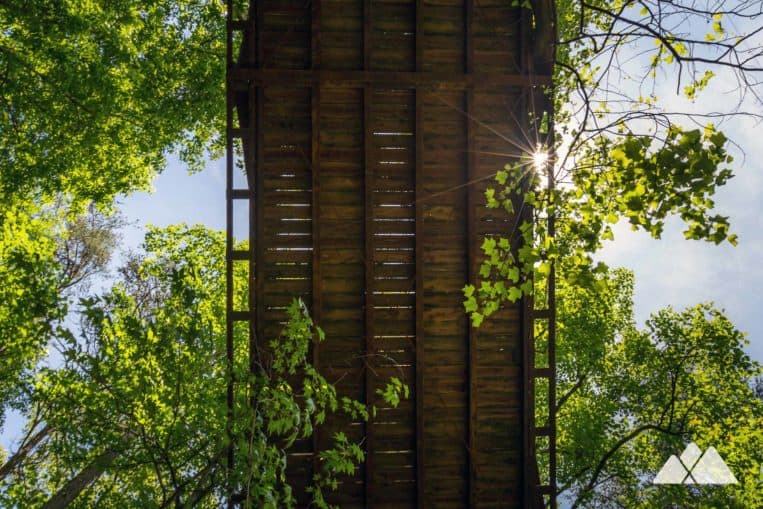
This former railway runs between steeply pitched rock outcrops, under a historic wooden bridge and crosses the Tallulah River by a suspension bridge. It’s a great morning run or fitness walk, and a popular paved bike route, too.
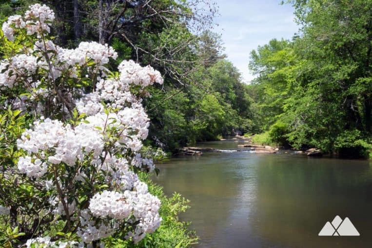 Upriver from the gorge, the Tallulah River flows tranquilly through the forest

Tallulah Gorge Shortline Trail: the run
The adventure begins at a trailhead off Terrora Circle (view maps and driving directions), following a wide, mostly-shaded, paved trail into the forest. Along the trail, interpretive signs pair trail features with suggested fitness activities, making the trail especially kid-friendly. The rail trail follows the route of a former rail line and runs nearly level, diving between towering rock outcrops that were blasted to make way for the train tracks that once ran this same path.
At .25 mile, the trail ducks under a historic wooden bridge.
The trail nears the banks of the Tallulah River at .5 mile, where benches offer a shaded resting spot under the leafy canopy of deciduous trees. The Shortline Trail crosses a trickling stream by a wooden bridge at .7 mile before entering a clearing.
To the left of the trail, fern carpet the sunlight-dappled banks of the Tallulah River. The route turns left at just under 1 mile, crossing the Tallulah River on a long wooden suspension bridge. Below, the river courses through shallow whitewater as it tumbles over its rocky streambed.
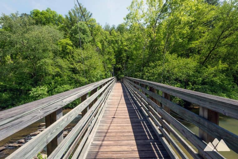
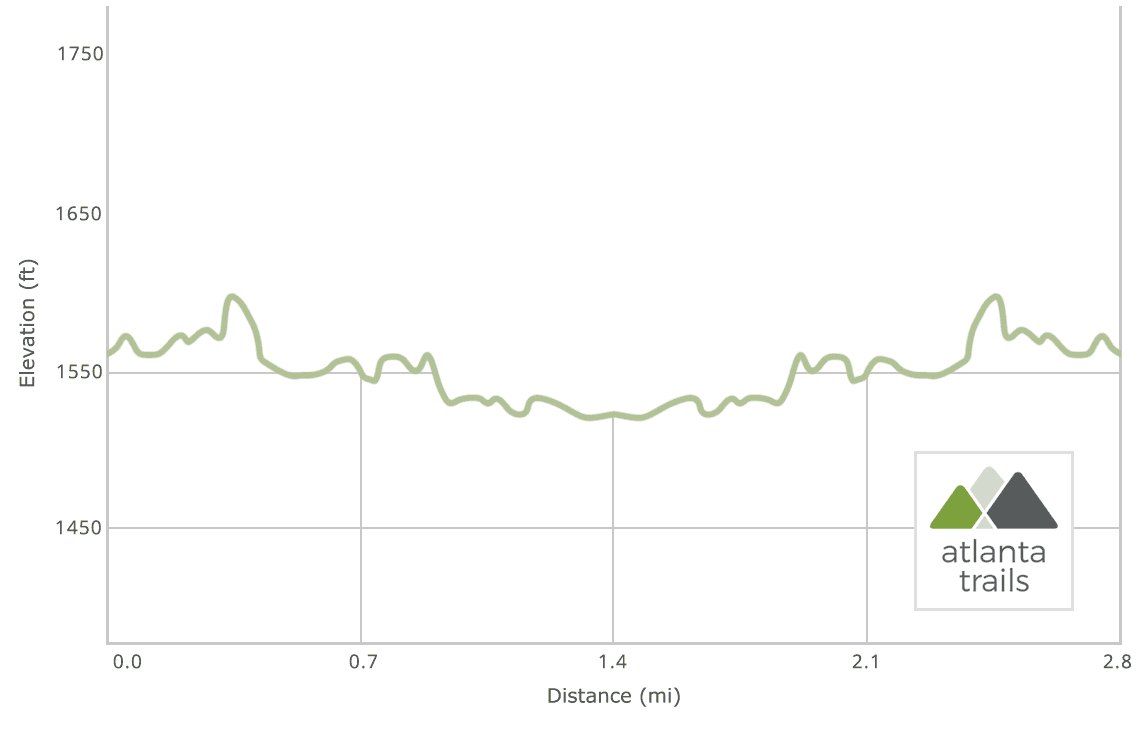
Reaching the end of the suspension bridge, the run hangs a left, following the river downstream along its western bank. The trail crosses a bridge before reaching an alternate trailhead at 1.25 miles, continuing its southward trek. The run reaches the end of the Shortline Trail at 1.4 miles, and turns to retrace its outbound steps to the trailhead. The run reaches the Terrora Circle trailhead at 2.8 miles, completing the adventure – or turning for another lap along the river’s scenic banks.

More adventures at Tallulah Gorge State Park
Camping at the gorge, or in the area with daylight left? Don’t miss the incredible hikes on this river located just downstream in the waterfall-filled, rocky gorge. Hike the Hurricane Falls Trail to explore the gorge’s lofty rim, and descend into the gorge by stairs and suspension bridge to visit an enormous, thundering waterfall. Or request a gorge floor permit from the park’s interpretive center, and scramble down the difficult Sliding Rock Trail to the Bridal Veil Falls rockslide and swimming hole.

Please Remember
Always leave no trace, pack out everything you pack in, and if you see trash, pick it up and pack it out.
Stay on the marked trail, tell someone where you're going, pack safety and wayfinding essentials, and don't rely on a mobile phone to find your way. Please always practice good trail etiquette. And before you go, always check the trailhead kiosk, official maps, and the park or ranger office for notices of changed routes, trail closures, safety information, and restrictions.
Tallulah Gorge State Park Shortline Trail Map, Directions & Details

Love the trail?
This trail is maintained thanks to the hard work of countless volunteers and donations from supporters of the Friends of Georgia State Parks. Please support them by making a donation or joining a volunteer day. Let's work together to keep these fantastic trails maintained and open for use!
Driving Directions
Parking
$5
GPS Coordinates
34.743383, -83.403783 // N34 44.603 W83 24.227
Elevation Profile