


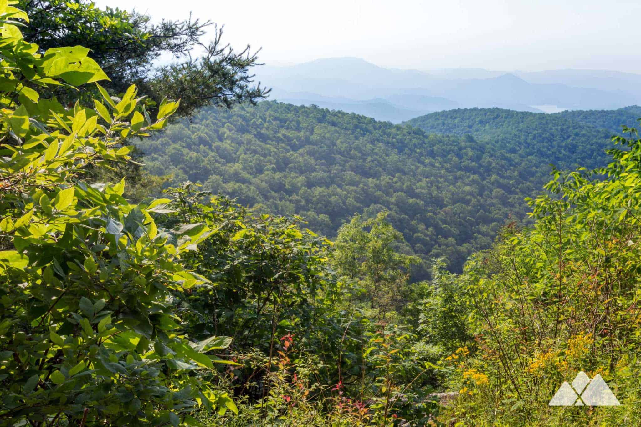
Hiawassee has always been one of our favorite basecamps for our favorite trail adventures. Those moments on a hike are always some of our favorite memories of all: the early morning scramble to the trailhead after grabbing a coffee and a quick bite in town. Following the trail, feeling every footstep deepening the connection to the forest and feeling everyday life just kind of fade away. Catching a water break from a breezy, view-packed summit or just downwind from a waterfall’s mist. There’s just something about hiking the southern Appalachian Mountains that has always touched our souls. And this Georgia mountain town offers nearby access to some of our state’s best hikes.
We truly fell in love with this stretch of the Georgia Mountains. We moved to Hiawassee from Atlanta several years ago to open Trailful, our hiking outfitter shop located on Main Street one block from the town square. This mountain town is home to Lake Chatuge, a beautiful mountain lake nestled below Georgia’s tallest mountain summit, Brasstown Bald. Thanks to the town’s close distance from the Appalachian Trail at Dicks Creek Gap and Unicoi Gap, the town is an official Appalachian Trail Community. And it’s a stop for many AT thru-hikers on their epic 2,000+ mile journey from Georgia to Maine. While the Appalachian Trail and Lake Chatuge are two of Hiawassee’s biggest draws, the town makes an excellent destination for chasing waterfalls and scaling summits, thanks to its proximity to an abundance of North Georgia’s best hiking trails. We’ve also found it to be a pretty amazing place to call home: there’s nothing better than hitting the AT for a sunset hike after closing our shop, and there’s nothing better than helping everyone from novice hikers to AT thru-hikers to outfit their next big adventure.
-
30 hikes within 30 miles: our favorite trails near Hiawassee, GA
Misty waterfalls, views from Georgia’s highest mountaintops, and a whole lot of fresh air, these thirty hikes follow our all-time favorite trails in the North Georgia and Western Carolina mountains. And they’re all located within a short, 30-mile drive from our hiking outfitter shop in downtown Hiawassee. Please remember, wherever your adventures take you, to always packing hiking safety essentials, tell someone where you’re going, and always pack out whatever you pack in and follow the principles of Leave No Trace. And after the adventure, stop by our shop downtown – it’d be great to say hello in person, and we’d love to share more of our favorite trails, dinner spots for a post-hike refuel, and local adventures!

Lake Chatuge Trail
distance from town: 3 miles
hike length: 1 mile, round trip
easySurrounded by rugged mountains, Lake Chatuge offers a picture-perfect setting for an outdoor adventure in North Georgia. Hike along the banks, catching beautiful lake and mountain views.
-
Appalachian Trail, Dicks Creek Gap to Bly Gap
distance from town: 10 miles
hike length: 17.4 miles, round trip
more difficultBackpack the AT from Dicks Creek Gap to Georgia’s northern border at Bly Gap, visiting a gnarled old oak near the state line and passing many fantastic backpacking campsites.
Appalachian Trail, Dicks Creek Gap to Powell Mountain
distance from town: 10 miles
hike length: 5.2 miles, round trip
more difficultHike the Appalachian Trail from Dicks Creek Gap just east of Hiawassee, climbing to stunning views of Lake Burton from the summit of Powell Mountain. It’s a workout, for sure, but the summit views are worth it.
-
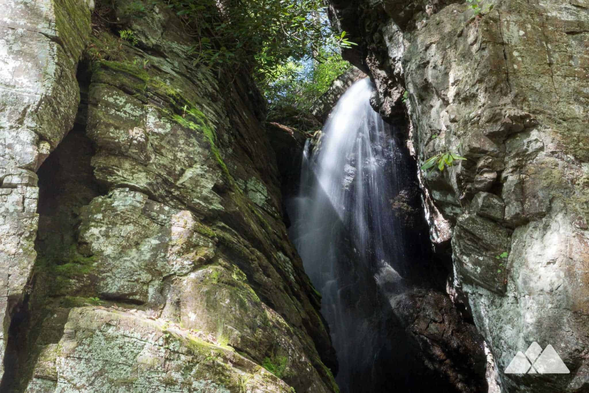
High Shoals Falls
distance from town: 11 miles
hike length: 2 miles, round trip
moderateFollow the High Shoals Trail through a lush, mossy creek valley, passing some prime backpacking campsites. The hike visits two stunning waterfalls, High Shoals Falls and Blue Hole Falls.
Appalachian Trail, Unicoi Gap to Rocky Mountain
distance from town: 12 miles
hike length: 5.1 miles, round trip
most difficultHike a challenging and scenic adventure, climbing from Unicoi Gap to Rocky Mountain, dropping into the wildflower-filled Indian Grave Gap on the Rocky Mountain Trail.
-
Appalachian Trail, Unicoi Gap to Chattahoochee Gap
distance from town: 12 miles
hike length: 8.9 miles, round trip
more difficultHike the Appalachian Trail just south of Hiawassee, climbing from Unicoi Gap to Blue Mountain. The trail explores a beautiful, fern and wildflower-filled forest and visits Chattahoochee Gap, where a tiny spring forms the headwaters of the Chattahoochee River.
Appalachian Trail, Indian Grave Gap to Tray Mountain
distance from town: 13 miles
hike length: 5 miles, round trip
more difficultHike to stunning views from Tray Mountain on this classic Georgia stretch of the Appalachian Trail, hiking from Indian Grave Gap through a lush, mossy forest filled with rhododendron and abundant wildflowers.
-
Arkaquah Trail at Brasstown Bald
distance from town: 14 miles
hike length: 11 miles, round trip
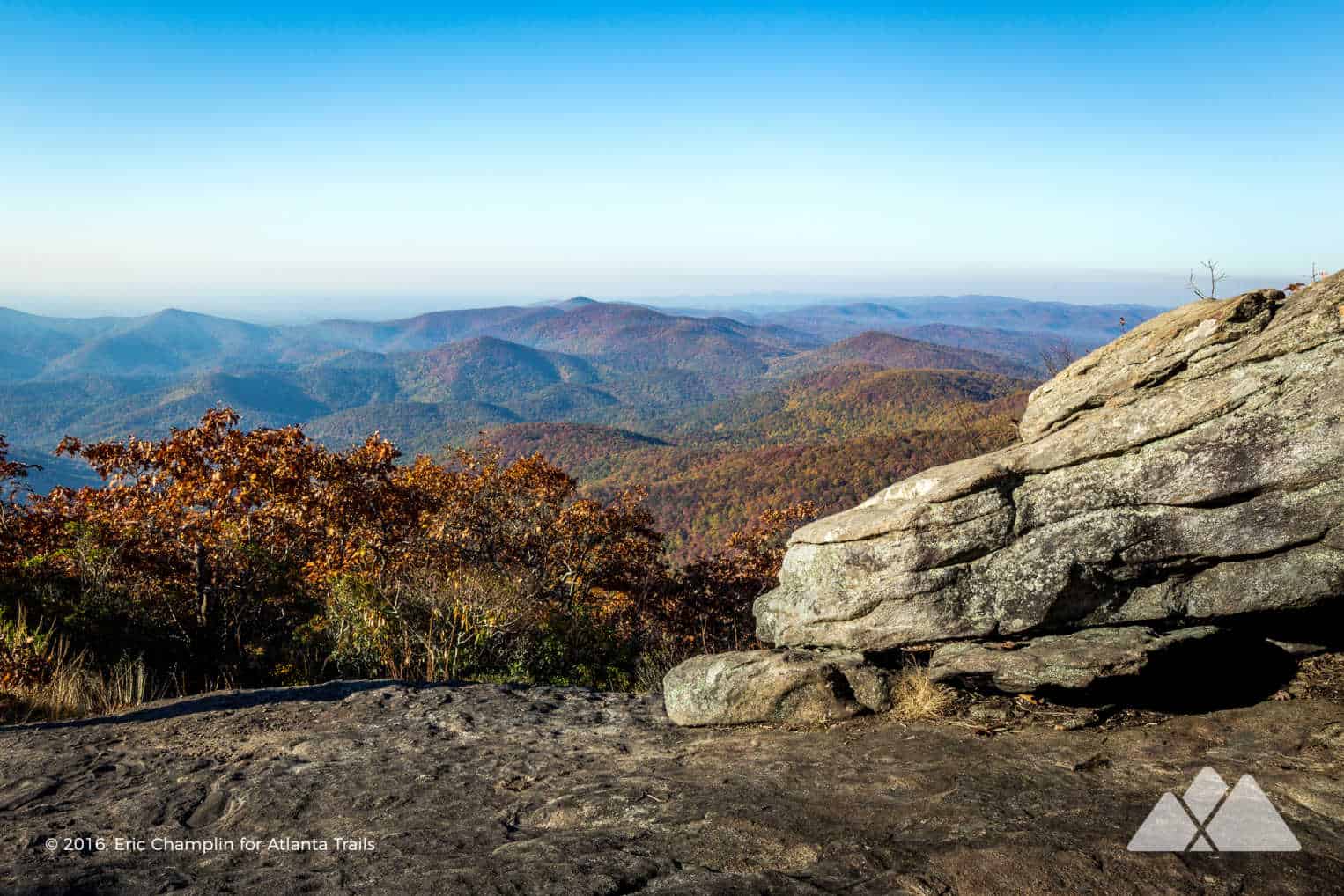
most difficultHike the Arkaquah Trail from Brasstown Bald, Georgia’s highest summit, and descend to Track Rock Gap to view ancient Native American petroglyphs. It’s one of the most difficult trails in Georgia, with an intense descent and an equally challenging climb back to the summit.
Brasstown Bald
distance from town: 14 miles
hike length: 1.1 miles, round trip
moderateFollow a short, steep, paved trail to Brasstown Bald, the tallest mountain in Georgia. The hike climbs through a grarly, mossy high-elevation forest to stunning, 360-degree views from the old wooden fire lookout platform on the mountain’s peak.
-
Bear Hair Gap Trail
distance from town: 22 miles
hike length: 4.1 miles, round trip
more difficultFollow the Bear Hair Gap Trail through a scenic stream-filled forest to beautiful views of Lake Trahlyta at Vogel State Park.
Hemlock Falls
distance from town: 22 miles
hike length: 2 miles, round trip
moderateHike the two-mile Hemlock Falls Trail at Lake Burton, exploring a waterfall-filled valley near Moccasin Creek State Park in North Georgia’s beautiful Rabun County.
-
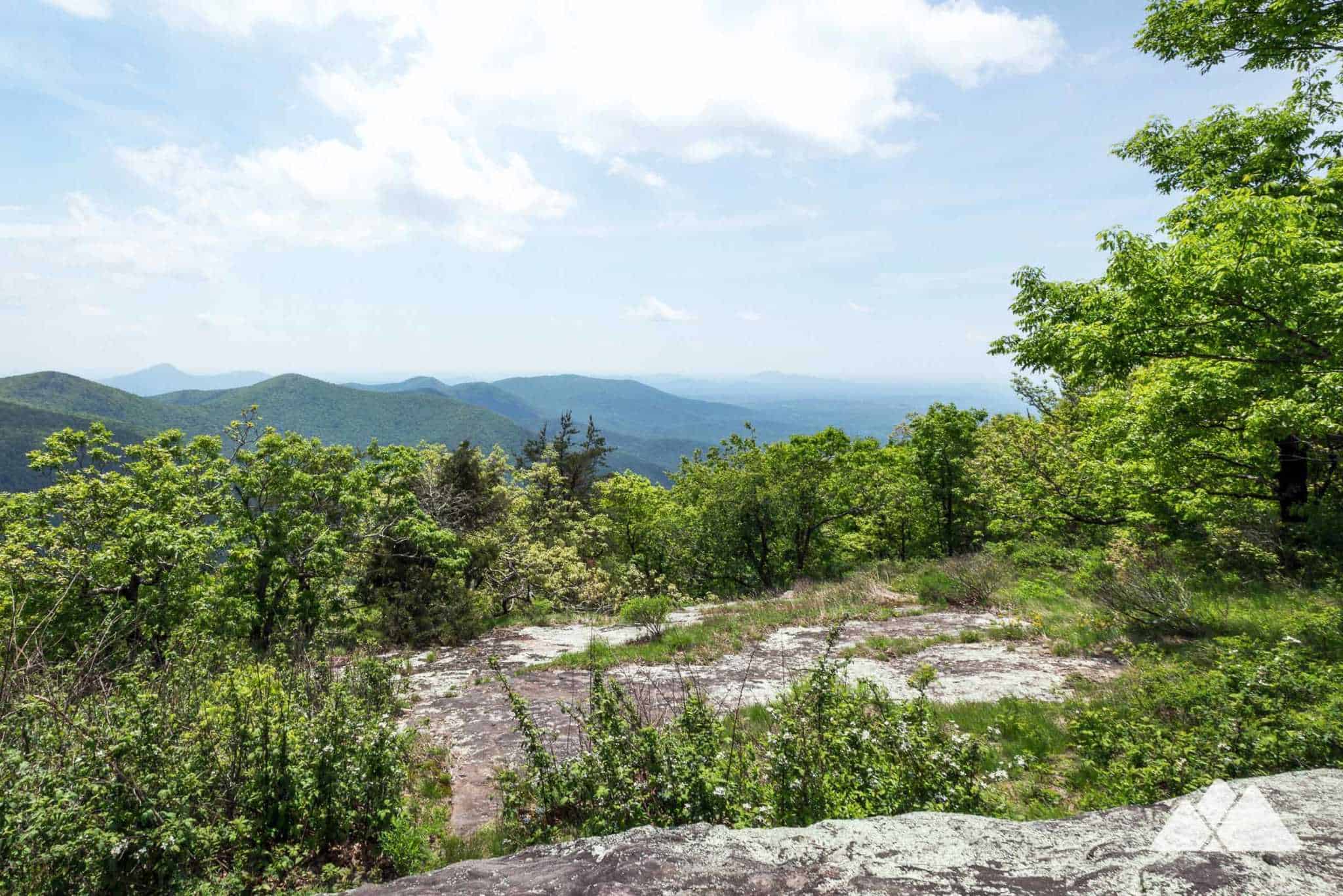
Vogel State Park to Blood Mountain
distance from town: 22 miles
hike length: 8.5 miles, round trip
more difficultHike the Coosa Backcountry Trail and the Duncan Ridge Trail at Vogel State Park, climbing to the Appalachian Trail to score beautiful vistas from the Blood Mountain summit.
Trahlyta Lake Trail
distance from town: 22 miles
hike length: 1.1 miles, round trip
easyHike the scenic Trahlyta Lake Trail at Vogel State Park, following the shore of the beautiful mountain lake to the stunning cascades of Trahlyta Falls and iconic views of Blood Mountain.
-
Smithgall Woods State Park
distance from town: 22 miles
hike length: 3-8 miles, round trip
moderateExplore Smithgall Woods State Park near Helen, hiking to tumbling waterfalls, gold mines, and the rocky, scenic creek bed of Dukes Creek.
Smith Creek Trail to Anna Ruby Falls
distance from town: 23 miles
hike length: 8.7 miles, round trip
more difficultHike to the enormous twin waterfalls at Anna Ruby Falls from the Smith Creek Trail from Unicoi State Park, exploring remnants of Georgia’s gold mining past along the way.
-
Blood Mountain via the Byron Reece Trail
distance from town: 23 miles
hike length: 4.3 miles, round trip
more difficultHike to the Blood Mountain summit on the Byron Reece Trail and Appalachian Trail. The adventure catches stunning views from the highest summit on the Appalachian Trail in Georgia.
Dukes Creek Falls
distance from town: 23 miles
hike length: 2 miles, round trip
moderateHike to multiple waterfalls and through a lush, green forest on the moderate, kid and dog-friendly Dukes Creek Falls Trail near Helen.
-
Blood Mountain to Cowrock Mountain on the Appalachian Trail
distance from town: 23 miles
hike length: 16 miles, round trip
difficultHike or backpack a sixteen-mile adventure on this view-packed stretch of the Appalachian Trail, exploring Blood Mountain, Neels Gap, Wolf Laurel Top, and Cowrock Mountain.
Blood Mountain Loop: Appalachian Trail and Freeman Trail
distance from town: 23 miles
hike length: 6 miles, round trip
most difficultClimb to the loft summit of Blood Mountain, following the Byron Reece Trail and Appalachian Trail to the top. Then loop back to the trailhead on Blood Mountain’s lesser-traveled side, following a challenging, boulder-filled route on the Freeman Trail. It’s a strenuous hike, no doubt, but it explores some incredibly beautiful and remote forest along the way.
-
Anna Ruby Falls
distance from town: 25 miles
hike length: 0.9 miles, round trip
easy to moderateFollow a paved path to Anna Ruby Falls, a tumbling pair of beautiful double waterfalls near Helen. The twin waterfalls spill from a towering cliff in wispy white tendrils.
Raven Cliff Falls
distance from town: 24 miles
hike length: 4.9 miles, round trip
moderateIt’s undoubtedly one of our all-time favorite waterfall hikes in the Southeast. Hike the Raven Cliff Falls Trail to a gorgeous waterfall that cascades through a 40-foot-tall, towering cliff, slicing the enormous rock outcrop in half.
-
Hogpen Gap to Unicoi Gap on the Appalachian Trail
distance from town: 25 miles
hike length: 29 miles, round trip
most difficultBackpack the Appalachian Trail from Hogpen Gap to Unicoi Gap, visiting the Low Gap and Blue Mountain AT shelters, and exploring the headwaters of the Chattahoochee River. This route is a fantastic two to three-day backpacking trip that explores some of Georgia’s most beautiful and rugged terrain.
Tesnatee Gap to Cowrock Mountain on the Appalachian Trail
distance from town: 25 miles
hike length: 2.5 miles, round trip
more difficultHike the Appalachian Trail from Tesnatee Gap to stunning Cowrock Mountain summit views on this 2.25 mile, out-and-back day hike in the Raven Cliffs Wilderness.
-
Yonah Mountain
distance from town: 27 miles
hike length: 4.4 miles, round trip
more difficultHike the Yonah Mountain Trail through a rocky, wildflower-filled forest, climbing this iconic mountain to exceptional summit views and great backpacking campsites near Helen.

Standing Indian Mountain on the Appalachian Trail
distance from town: 27 miles
hike length: 5 miles, round trip
more difficultHike the AT to outstanding summit views on Standing Indian Mountain. The hike climbs steadily from Deep Gap and visits the Standing Indian AT shelter along the way.
-
Desoto Falls
distance from town: 29 miles
hike length: 2.2 miles, round trip
easy to moderateHike the two-mile Desoto Falls Trail near Helen to a pair of waterfalls where (legend says) someone found a piece of armor from Hernando de DeSoto’s expedition through the south nearly 500 years ago.
Pinnacle Knob from the Bartram Trail
distance from town: 29 miles
hike length: 8.1 miles, round trip
more difficultHike the AT to outstanding summit views on Standing Indian Mountain. The hike climbs steadily from Deep Gap and visits the Standing Indian AT shelter along the way.
-
Angel Falls
distance from town: 30 miles
hike length: 1.75 miles, round trip
moderateHike the Angel Falls Trail from the Lake Rabun Beach Campground. The adventure visits two beautiful waterfalls, Angel Falls and Panther Falls, set in a beautiful creek valley near Clayton.

Albert Mountain on the Appalachian Trail
distance from town: 30 miles
hike length: 4 miles, round trip
more difficultHike the Appalachian Trail in North Carolina, climbing to the Albert Mountain fire tower, hiking through Bearpen Gap, and catching stunning views along the Big Butt Ridge to Mooney Gap.
-
Minnehaha Falls
distance from town: 30 miles
hike length: 0.4 miles, round trip
easyIt’s the shortest hike to make this list, but this waterfall is undoubtedly one of the finest in the Georgia Mountains. Hike the Minnehaha Falls Trail, a quick, easy, kid-friendly hike on the shores of Lake Rabun. The trail explores a beautiful, cascading waterfall set in a lush forest filled with gnarly-branched rhododendron.
-
What to pack?
Our favorite hiking gear
Ready to hit the trail, but wondering what to pack? Our hiking gear list features our favorite, trail-tested hiking gear for day hikes in the Georgia backcountry. No matter what you pack in, pack it all back out. Please leave no trace and help preserve Georgia’s beauty.


Please Remember
Always leave no trace, pack out everything you pack in, and if you see trash, pick it up and pack it out.
Stay on the marked trail, tell someone where you're going, pack safety and wayfinding essentials, and don't rely on a mobile phone to find your way. Please always practice good trail etiquette. And before you go, always check the trailhead kiosk, official maps, and the park or ranger office for notices of changed routes, trail closures, safety information, and restrictions.


