Hike the Sweetwater Creek White Trail and Red Trail, a scenic 4-mile loop to Civil War mill ruins, a tumbling creek and quiet meadows at Georgia’s Sweetwater Creek State Park just west of Atlanta.
(round trip)
moderate
friendly
LOCATION:Sweetwater Creek State Park near Atlanta, Georgia
PACK:our Osprey day pack and our hiking gear list
Tumbling whitewater. Rocky bluffs. Wide vistas. Civil War mill ruins. There’s a whole lot of outdoor beauty to be found at Sweetwater Creek State Park – at mere miles from Atlanta, this Georgia State Park offers some of the metro area’s best hiking and running trails.
This two-trail combo hikes the park’s Red Trail and White Trail, making a moderate 4-mile loop along Sweetwater Creek’s rocky, sandy shores and through a beautiful young forest. The longest trail at the state park, this hike also treks the park’s most diverse landscapes, exploring lesser-traveled trails to a trickling tributary, remote forest, and green, grassy meadows.

Sweetwater Creek State Park is located just outside Atlanta’s I-285 perimeter and offers more than 10 miles of fantastic running and hiking trails near the banks of the rushing, whitewater-filled creek and its surrounding forest. For more fantastic hiking and running trails at the park, check out our Sweetwater Creek hiking, running and adventure guide.

Sweetwater Creek White Trail: the hike
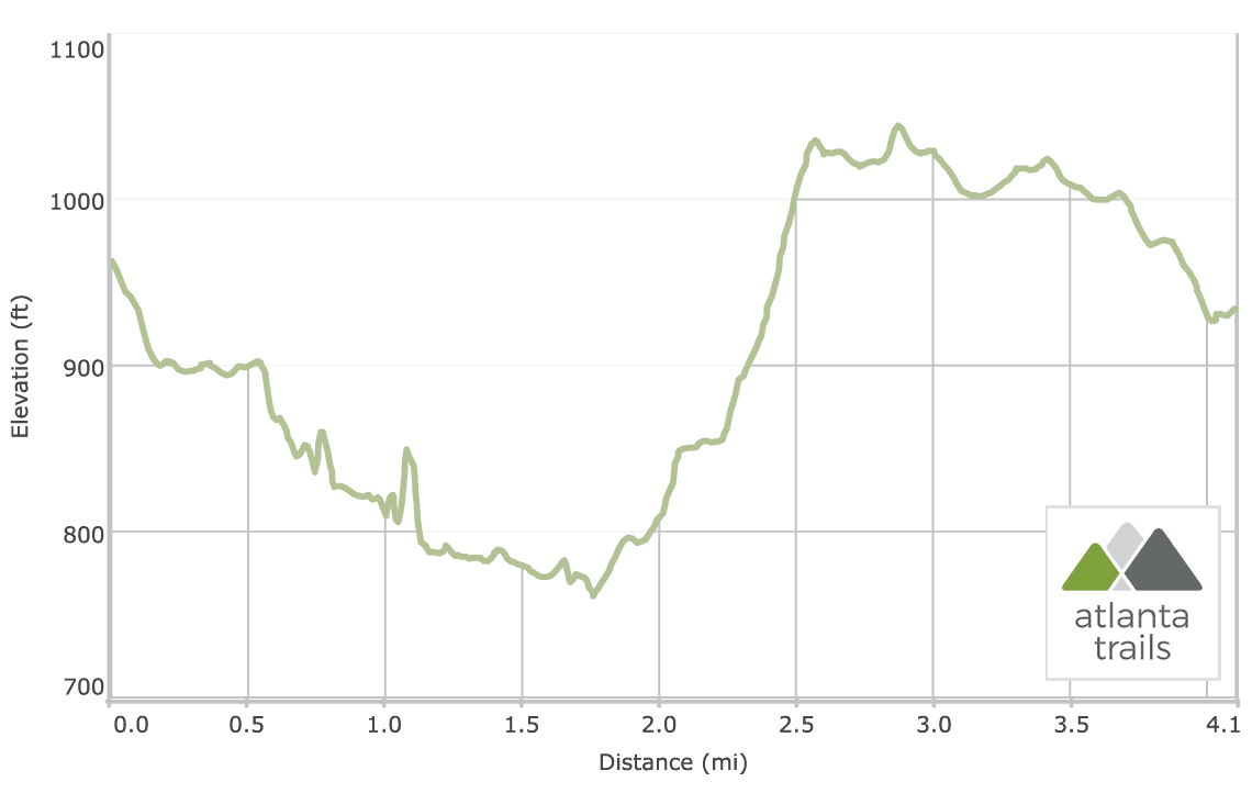
The trail departs the Sweetwater Creek State Park visitor center, diving through a young deciduous forest on the meandering, elevation-dropping red-blazed trail and reaching Sweetwater Creek’s shores at .2 mile. The hike turns right at the trail junction to follow the creek downstream, reaching the New Manchester Mill ruins at .6 mile. The shell of the multi-story brick factory, destroyed in the Civil War by Union troops during the march to Atlanta, towers over the rushing creek.

The hike descends stairs on the mill’s right side. Reaching Sweetwater Creek’s sandy banks, the upstream views open dramatically, revealing tumbling whitewater and angular creek shoals. Following Sweetwater’s flow downstream, the Red Trail alternates between leisurely strolls on the creek’s sandy shores and scrambles over rocky, blocky outcrops. The creek crashes through turbulent whitewater and rushes through angular shoals before pooling in calm, grassy, glassy waters.

The trail grabs broad, sweeping views from two massive rock bluffs along Sweetwater Creek’s shores, one at .75 miles and the second at 1.1 miles. At the second overlook, the towering vantage point offers views of the “falls,” an extended stretch of spilling, tumultuous whitewater and small waterfalls. The Red Trail ends at a trail intersection after climbing stairs from the outcrop. This hike on the White Trail loop veers left, hiking south and descending the bluff via a series of stairs.
The White Trail hugs the wide meanders of Sweetwater Creek. The creek’s flow vast and serene, a contrast to the churning, waterfall-filled whitewater upstream. Glassy pools of water reflect the lush, vegetated islands dotting the creek’s bed.

The trail follows the river’s flow through a wide southwest meander before scrambling up a rock outcrop at 1.6 miles. The White Trail veers right from Sweetwater Creek at 1.75 miles, turning westbound in an arc along a small tributary stream, Jack’s Branch. (Note: this hike does not cross the wooden bridge over the creek.) The White Trail follows Jacks’ Branch upstream, reaching Jack’s Lake at just over 2 miles. The trail turns sharply right and then quickly left at the western edge of the lake. The hike treks an old gravel roadbed, climbing a ridge overlooking the lake below and gaining over 200 feet elevation in the next half mile. The trail courses through a broad arc before reaching a cleared, grassy meadow at 2.5 miles.
Departing the meadow, the trail levels elevation, hiking through a series of well-signed gravel road intersections before passing the state park’s picnic and playground areas. The trail begins a steady decline at 3.5 miles, dropping elevation to loop east toward the park’s visitor center and trailhead, completing at just over 4 miles.
Note: slippery rocks and fast moving water can be extremely dangerous! Please don’t climb, stand on, swim near, or jump from any waterfall.

More Sweetwater Creek adventures
Explore the park’s wildlife-filled, grassy lake shore by kayak or canoe. Paddle the glassy waters of Sweetwater Creek’s reservoir lake by stand-up paddleboard. Camp in the park’s brand new campground with modern facilities, or overnight in style in Sweetwater Creek’s new yurt village. Find more ideas for adventure in our Sweetwater Creek State Park destination guide.

Please Remember
Always leave no trace, pack out everything you pack in, and if you see trash, pick it up and pack it out.
Stay on the marked trail, tell someone where you're going, pack safety and wayfinding essentials, and don't rely on a mobile phone to find your way. Please always practice good trail etiquette. And before you go, always check the trailhead kiosk, official maps, and the park or ranger office for notices of changed routes, trail closures, safety information, and restrictions.
Sweetwater Creek White Trail Map, Directions & Details

Love the trail?
This trail is maintained thanks to the hard work of countless volunteers and donations from supporters of the Friends of Georgia State Parks. Please support them by making a donation or joining a volunteer day. Let's work together to keep these fantastic trails maintained and open for use!
Driving Directions
Parking
$5
GPS Coordinates
33.752600, -84.628350 // N33 45.156 W84 37.701
Elevation Profile