Hike the Appalachian Approach Trail from Amicalola Falls to Springer Mountain, the southernmost end of the AT in Georgia.
(round trip)
difficult
friendly
LOCATION:Appalachian Trail near Ellijay, Georgia
PACK:our Osprey day pack and our hiking gear list
OFFICIAL MAP: Appalachian Trail, Trails Illustrated (find it at Trailful Outdoor Co.)
The Appalachian Trail is the longest hiking-only trail in the world, stretching more than 2,000 miles from Georgia to Maine. Every year, thousands of thru-hikers follow its enormously long, meandering, view-packed path – and day-hikers and weekend backpackers flock to the trail by the millions. From its official southern start at Georgia’s Springer Mountain, the trail makes a northbound journey of epic proportions, trekking through 14 states.
Headed northbound from Springer? There’s more than one way to summit the mountain and begin the AT. While access to the trail’s southernmost end is available at the Springer Mountain trailhead, the AT Approach Trail also offers access to Springer Mountain from Amicalola Falls, Georgia’s tallest waterfall.

This hike on the blue-blazed AT Approach Trail departs from the summit of Amicalola Falls, rolling through a beautifully diverse forest to the final southern blaze of the Appalachian Trail. While it’s a longer-distance option to access Springer Mountain, it’s an incredibly scenic one – and unlike the Springer trailhead, doesn’t require backtracking southbound before starting a northbound journey on the AT.
The AT Approach Trail makes a great, long day hike, complete with mountaintop vistas and views of a stunning waterfall. And with multiple campsites along the way, makes a great backpacking trip – whether it’s an overnight, Georgia section hike, or the beginning of a long-distance adventure on the AT.
AT Approach Trail to Springer Mountain: the hike
The hike departs from the AT Approach trailhead near the crest of Amicalola Falls, sharing its initial stretch with the Hike Inn Trail before veering left at .3 mile and following blue trail blazes. (Haven’t hiked Amicalola Falls? Grab some additional mileage, a great workout and an up-close view of the waterfall’s beautiful cascades on the two mile Amicalola Falls Loop.)
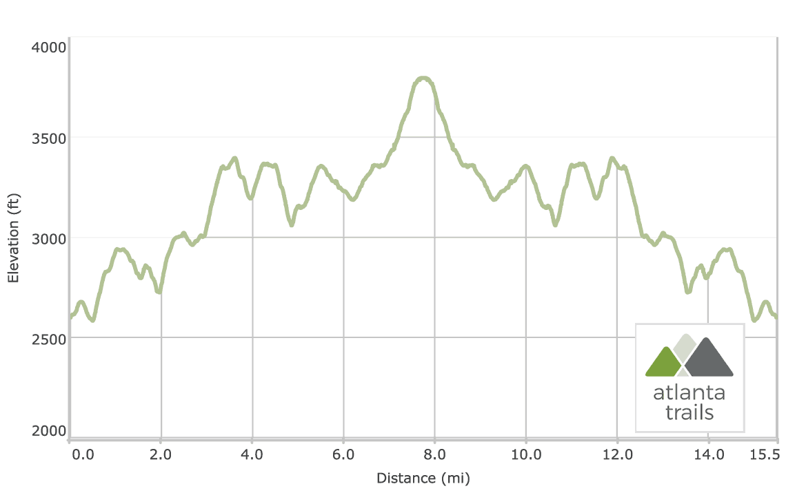
The trail descends through a gnarled rhododendron and laurel-filled forest, green moss flanking the trail’s sides. The AT Approach Trail crosses a small creek, and then a road, at .5 mile. The trail climbs elevation, cresting the summit of a small knob at just over 1 mile. The trail descends through a forest of spindly, young poplar trees and a forest floor filled with vibrant bamboo grasses.

The Appalachian Approach Trail hikes across a gravel road at just over 2 miles, steadily gaining elevation through a deciduous forest speckled with strewn, mossy boulders. Young hemlock trees sporadically dot the forest, their fine-needled branches filling the air with fresh, piney fragrance. The trail dips elevation slightly at 2.5 miles to cross a ridge spotted with rock piles, views extending between tree trunks and foliage. The trail grabs elevation, reaching a campsite at 3.1 miles before turning east, continuing an ascent to Springer. Large chunks of marble dot the hillside, their white surface glowing brilliantly against the colorful, saturated forest floor.
The trail crests the summit of Amicalola Mountain at 3.6 miles, diving through low, dense, thorny ground cover flanking the trail’s side. The trail passes a campsite on trail right, crosses a gravel road, and descends from the summit to cross the road again at just under 4 miles.
The AT Approach Trail reaches an intersection with the Hike Inn Trail at 4.25 miles, continuing northeast to follow blue blazes toward Springer Mountain. The trail levels, hiking past a pair of campsites before plunging elevation at 4.5 miles.

The trail reaches Nimblewill Gap at 4.9 miles, crossing a gravel road and passing a metal sign commemorating the 1968 crash site of a small airplane. Departing Nimblewill Gap, the trail quickly regains elevation, climbing a rocky ridge. Between-the-trees views emerge on trail right. The trail ascends through a boulder and fern-filled deciduous forest, nearing the summit of Black Mountain at 5.5 miles. A blue-blazed trail departs to the right at 6.2 miles, leading to a seasonally-available water source, and departs left to the Black Gap AT shelter.
Departing Black Gap, the Appalachian Approach Trail climbs solidly uphill, climbing the lower elevations of Springer Mountain’s southern slope. The trail turns due north to approach Springer at 6.4 miles, scrambling over boulders in a thorny, vine-filled forest. The elevation gain intensifies at 7 miles as the trail meanders through a series of switchbacks.

The AT Approach Trail reaches the Springer Mountain summit, and the official southern end of the Appalachian Trail, at 7.8 miles, having climbed 600 feet elevation since Black Gap. Views extend westward through Springer’s abundantly forested summit.
On the Springer summit, two plaques commemorate the southernmost white blaze of the Appalachian Trail. A trail log in a metal vault holds the hopeful writings of those beginning the trail’s epic 2000+ mile journey here at Springer, and the celebratory writings of those just finishing their multi-month adventure from Maine.

Following the white blazes to Maine?
A huge congrats on making your first steps on your epic journey! Our crew owns Trailful Outdoor Co, a A.T resupply and full-service hiking outfitter shop in Hiawassee, an official AT trail town in the Georgia mountains. We’re a short shuttle away from Unicoi Gap (mile 52) and Dicks Creek Gap (mile 69), and we stock a full line of resupply, hiking apparel, tents, sleeping gear, boots and shoes, backpacks, trekking poles, meals, fuel, cookware, and backpacking gear. Check out our North Georgia thru-hiker resupply and outfitter info for details on our A.T. thru-hiker services, including mail drops, backpacking gear, technical apparel, footwear, and our hiker-friendly trail town in the Georgia mountains.
Out for a day hike or overnight?
This out-and-back route on the AT Approach Trail departs Springer’s summit, doubling back on the Approach Trail toward the Amicalola Falls trailhead to complete the hike at 15.6 miles. For a change of scenery on the return hike, turn left on the Hike Inn Trail at 11.3 miles, visiting the Len Foote Hike Inn eco-lodge on the journey back to Amicalola Falls. (The alternate return via the Hike Inn Trail will add 1.7 miles to this hike’s mileage, reaching Amicalola at 17.3 miles.)
Please Remember
Always leave no trace, pack out everything you pack in, and if you see trash, pick it up and pack it out.
Stay on the marked trail, tell someone where you're going, pack safety and wayfinding essentials, and don't rely on a mobile phone to find your way. Please always practice good trail etiquette. And before you go, always check the trailhead kiosk, official maps, and the park or ranger office for notices of changed routes, trail closures, safety information, and restrictions.
Love the trail?
This trail is maintained thanks to the hard work of countless volunteers and donations from supporters of the Georgia Appalachian Trail Club. Please support them by making a donation or joining a volunteer day. Let's work together to keep these fantastic trails maintained and open for use!
Driving Directions
Parking
$5, or included with a Friends of Georgia State Parks and Historic Sites membership.
GPS Coordinates
34.566933, -84.243583 // N34 34.016 W84 14.615
Elevation Profile


