Run, walk or bike the five-mile, paved Panola Mountain PATH Foundation trail through Panola Mountain State Park to the shores of the glassy Alexander Lake.
(round trip)
paved
friendly
LOCATION:Panola Mountain State Park near Atlanta, Georgia
PACK:our Osprey day pack and our hiking gear list
Filled with shady forests, lakes, and immense, exposed granite fields covered in lichen, moss, and wildflowers, Panola Mountain State Park offers amazing adventures just east of Atlanta. Plant life and wildlife thrive on the mountain’s varied terrain and its beautiful, natural ecosystems.
This mountainous area is well-loved by hikers, including the popular hiking trails at Arabia Mountain and guided hikes on the Panola Mountain summit. And its popularity is quickly growing with runners and cyclists, too, thanks to an incredible network of more than thirty miles of paved trails that meander through the parks in the Arabia Mountain National Heritage Area.

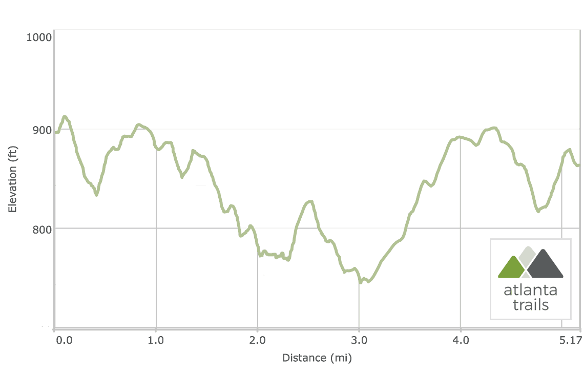
The Panola Mountain PATH Trail runs through the mountain’s scenic, granite-covered landscape to the still, reflective water of Alexander Lake. The trail’s rolling elevation catches views of the mountain’s unique natural ecosystems from a long wooden platform, arcs over the marshy shoreline of Alexander Lake on a raised boardwalk, runs a causeway between the Upper and Lower Alexander Lakes, and trails through a historic barn over the course of 5 miles. It’s a run – or fitness walk or bike trail – full of interest and beauty.

The Panola Mountain PATH Trail
The adventure begins at a trailhead near Panola Mountain State Park’s main entrance (view maps and driving directions). The trail follows the contours of a road for the first quarter mile before darting into a cleared forest, dipping elevation to cross two trickling streams at just under a half mile. Pine and hardwood trees tower over the path, and lichen-covered rock outcrops bordered with colorful wildflowers dot the trail’s sides.

The trail reaches a trail junction at 1.15 miles. A left turn here follows an extended-length boardwalk over Panola Mountain’s fragile, lichen and moss-encrusted ecosystems. The boardwalk terminates in a wooden platform that offers excellent views of a huge expanse of exposed granite. The plant life that thrives on these rocky stretches at the park is fragile, rare, and slow-growing, so please stay on the boardwalk and paved trails throughout this run to help preserve the mountain’s natural beauty.
Alexander Lake Loop Trail
Departing the viewing platform, the trail continues its eastbound route in a rolling descent to Alexander Lake. The trail meets a second intersection at 1.85 miles, turning right at the intersection to follow the Alexander Lake Loop Trail counter-clockwise. The trail dives through a forest filled with massive boulders before curving to reach the wooden Alexander Lake boardwalk at 2.2 miles. The boardwalk arcs over a grassy wetland bordering the still, glassy water of Alexander Lake, offering beautiful mid-run views.

The Alexander Lake Trail loops eastward, climbing a small rise above the lake’s shore before turning northwest at 3 miles to cross a small earthen dam. The run crosses the dam, catching glassy lake views from both sides of the trail, and arcs to depart the lake’s shore. The run turns right at a trail intersection at 3.5 miles, following the trail through a large, historic barn.

Looping back to the trailhead
Exiting the barn, the run takes a right turn at the intersection, retracing its outbound route on the Panola Mountain PATH Trail back to the trailhead. The run continues to climb elevation before cresting at 4 miles. The trail rolls elevation for the remainder of the run, reaching the trailhead at 5.15 miles and completing the adventure.

Please Remember
Always leave no trace, pack out everything you pack in, and if you see trash, pick it up and pack it out.
Stay on the marked trail, tell someone where you're going, pack safety and wayfinding essentials, and don't rely on a mobile phone to find your way. Please always practice good trail etiquette. And before you go, always check the trailhead kiosk, official maps, and the park or ranger office for notices of changed routes, trail closures, safety information, and restrictions.
Panola Mountain PATH Trail Map, Directions & Details

Love the trail?
This trail is maintained thanks to the hard work of countless volunteers and donations from supporters of the Arabia Mountain Heritage Area Alliance. Please support them by making a donation or joining a volunteer day. Let's work together to keep these fantastic trails maintained and open for use!
Driving Directions
Parking
$5
GPS Coordinates
33.622517, -84.173183 // N33 37.351 W84 10.391
Elevation Profile