One of the top running spots in Athens near the UGA campus, the State Botanical Garden of Georgia offers mile after mile of scenic, rolling running and hiking trails.
(round trip)
unpaved
allowed
LOCATION:near the University of Georgia campus in Athens, GA
PACK:our Osprey day pack and our hiking gear list
Drive an hour east of Atlanta and you’ll find yourself in the heart of Athens. Best known as the home of the Georgia Bulldogs, the Classic City is also a hotspot for outdoor fun, especially hiking and trail running. The State Botanical Garden of Georgia, just minutes from downtown and the UGA campus, is a 313-acre facility operated by the University of Georgia and a favorite with both locals and area visitors looking to spend some time outside enjoying nature’s beauty. In addition to the wide variety of ornamental, international, and native gardens, indoor conservatory, and multiple event spaces, the Garden also offers an extensive set of scenic nature trails totaling over six miles.
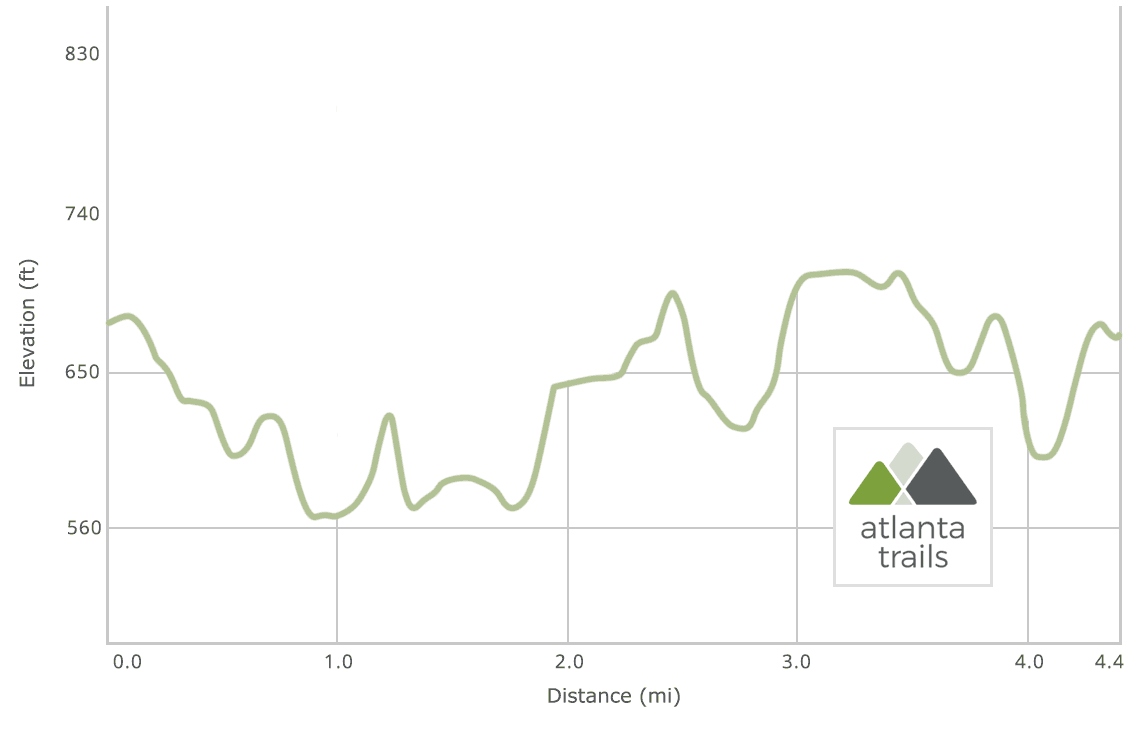
Popular with runners, walkers, and nature enthusiasts alike, there are a total of seven well-marked, color designated trails spanning the perimeter of the property appealing to visitors of all skill levels. The orange trail and white trail each depart from the parking area in opposite directions and meet along the bank of the Middle Oconee River to form a 4.4-mile loop. The remaining five trails — red, yellow, green, blue, and purple — intersect at various points throughout the longer orange and white trails and serve as connector, shortcut, or special interest trails.

Made of compacted soil along a mostly flat path with a short elevation gain towards the end, the trails at the gardens are perfect for families, beginning hikers, or trail runners looking for a quick and challenging workout.

State Botanical Garden Orange & White Trails
At the start of the orange trail, just off the main entrance road and steps from the parking area, sits an information shelter full of helpful wildlife guides, habitat news, and printed trail maps. Prefer to go paperless? No problem! Thanks to the Department of Geography at UGA and the Center for Geospatial Research at UGA, visitors can also map a hike or run using a detailed and interactive trail map on any smartphone through the Google Maps app.
The orange trail begins with a short descent along a shady dirt path through various hardwoods and evergreens before meeting a small creek that flows into the Middle Oconee River. As the trail winds alongside the rocky creek and over several footbridges, it passes through multiple plant communities and diverse landscapes marked with interpretive signs detailing the unique characteristics of each area.

At the bank of the Middle Oconee River, the orange trail takes a sharp right to continue along the scenic waterfront through a tunnel of rhododendron and other native flora. Just a few steps ahead on the right is the quarter-mile purple trail which leads back to the Flower and Heritage Gardens. At 1.2 miles, the orange trail meets the white trail. Here, visitors have the option of turning right onto the white connector trail leading to the Native and Shade Gardens or continuing straight on the main white trail alongside the river for a longer, more challenging trek.

Taking the longer route, the white trail continues to follow the water’s edge for a half-mile before turning away from the river and gently climbing through hardwood and pine forests, abundant with various ferns, wildlife, and, especially in the spring, native berries and wildflowers. This portion of the white trail frequently intersects with the remaining red, yellow, green, and blue trails and crosses under the nearby power line through tall grasses three times. In addition to several benches placed along the path, two shelters are located on this side of the property as well providing storm cover, a place to rest, and a large, posted map.
At approximately 3.2 miles, the white trail comes to an end near the parking area, opposite the orange trail, completing the 4.4-mile orange and white trail loop.

State Botanical Garden of Georgia: know before you go
Although the garden is a UGA-operated facility, it is open to the public 7-days a week, with the exception of official university holidays. Parking and admission to the gardens, conservatory, and trails is free, however donations are appreciated and can be made at the Visitor’s Center. Bicycles are not allowed on the nature trails and dogs are not permitted on the property, including nature trails.

Please Remember
Always leave no trace, pack out everything you pack in, and if you see trash, pick it up and pack it out.
Stay on the marked trail, tell someone where you're going, pack safety and wayfinding essentials, and don't rely on a mobile phone to find your way. Please always practice good trail etiquette. And before you go, always check the trailhead kiosk, official maps, and the park or ranger office for notices of changed routes, trail closures, safety information, and restrictions.
State Botanical Garden of Georgia Trail Map, Directions & Details

Driving Directions
Parking
Free parking; donations encouraged.
GPS Coordinates
33.902958, -83.382535 // N33 54.178 W83 22.954
Elevation Profile