Hike the Springer Mountain Loop, following the Appalachian Trail and Benton MacKaye Trail to explore multiple view-packed overlooks and a beautiful stream-filled valley.
(round trip)
difficult
friendly
LOCATION:Appalachian Trail near Ellijay, Georgia
PACK:our Osprey day pack and our hiking gear list
OFFICIAL MAP: Appalachian Trail, Trails Illustrated Map (find it at Trailful Outdoor Co.)
Springer Mountain isn’t the highest summit in North Georgia, and the views aren’t quite as wide as its Georgia rivals like Blood Mountain or Rabun Bald.
But Springer Mountain ranks high on our lists of favorite Georgia hikes, and for a good reason: the southernmost blaze of the Appalachian Trail lies on the Springer summit. It’s here, on this mountaintop near Amicalola Falls, that an epic, 2,000+ mile adventure begins (or ends) for the thousands of thru-hikers that journey the AT’s entire length.
 Above: hike to summit views at the Springer Mountain summit, the southernmost end of the Appalachian Trail in Georgia
Hike this 4.7-mile loop on the AT and Benton MacKaye Trail, catching beautiful mountaintop views from multiple overlooks, hiking through a scenic hardwood forest and crossing through a shady, mossy stream valley. Departing the often-crowded Springer Mountain summit, this loop on the Benton MacKaye Trail (BMT) grabs some solitude from a second summit overlook, one that rivals the view from the true Springer Mountain summit.
The BMT, named after the founder of the Appalachian Trail, also visits a memorial to Benton MacKaye near on Springer Mountain and explores a rhododendron-filled creek valley before looping back to the trailhead. It’s a gorgeous hike in any season, but one of our favorite Georgia hikes in winter, when the overlook vistas open to broad and frosty mountaintop views. And it’s also especially beautiful in autumn’s beautiful leaf color.

Springer Mountain Loop on the Appalachian Trail
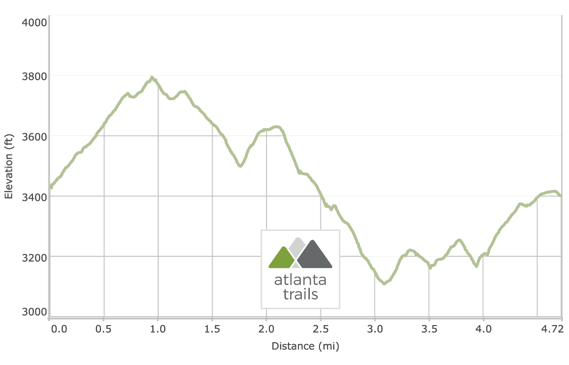
The Springer Mountain Loop departs the Springer Mountain parking area on Forest Road 42 (view maps and driving directions), following the white, rectangular blazed Appalachian Trail westbound across the gravel forest road.

The hike arcs south toward Springer Mountain, steadily gaining more than 350 feet elevation and climbing through a rocky, boulder-filled forest. The hike passes the Benton MacKaye Trailhead on trail left before reaching the Springer summit at just under 1 mile, catching summit views of the southern Appalachian mountains.
The Springer Mountain Loop departs the summit, descending on the Appalachian Trail to the Benton Mackeye Trail. The hike reaches the BMT trailhead at 1.15 miles, turning right to follow the BMT’s white diamond trail blazes northbound.
The BMT passes a memorial to Benton MacKaye at 1.25 miles before arcing to begin a continual, eastbound descent from the Springer Mountain summit. The hike levels at 1.75 miles before starting a brief, 125-foot ascent of Ball Mountain. The trail reaches a side trail to the right at 2.25 miles, marked by a double-diamond blaze.

The hike follows this short spur to grab stunning views from a nearby overlook. The broad, long-range view is especially beautiful in the fall, when saturated leaf color dots the surrounding peaks – and the view rivals the more popular, and often crowded, Springer Mountain summit.

The Springer Mountain Loop departs the overlook, rejoining the Benton MacKaye Trail and turning right. The hike crosses Forest Road 42 at Big Stamp Gap and follows the BMT westbound, climbing elevation and switching back through a canopy of mountain laurel and rhododendron.

The hike reaches the first of several stream crossings at 3.5 miles, hiking through the shallow bed of Davis Creek. The damp, water-filled creek valley is a contrast to the dry, windswept landscape of Springer Mountain summit: vibrant green moss covers water-rounded boulders, and abundant wildflowers add vibrant color to the forest floor.
The Benton MacKaye Trail crosses Davis Creek several times before climbing elevation, rising to meet a junction with the Appalachian Trail at 4.4 miles. This route on the Springer Mountain Loop turns left at this intersection, following the white rectangular blazes of the AT in a southwest arc to the trailhead. The hike reaches the Springer Mountain parking area at 4.7 miles, completing the adventure.

Please Remember
Always leave no trace, pack out everything you pack in, and if you see trash, pick it up and pack it out.
Stay on the marked trail, tell someone where you're going, pack safety and wayfinding essentials, and don't rely on a mobile phone to find your way. Please always practice good trail etiquette. And before you go, always check the trailhead kiosk, official maps, and the park or ranger office for notices of changed routes, trail closures, safety information, and restrictions.
Springer Mountain Loop on the Appalachian Trail and Benton MacKaye Trail Map, Directions & Details

Love the trail?
This trail is maintained thanks to the hard work of countless volunteers and donations from supporters of the Benton MacKaye Trail Association. Please support them by making a donation or joining a volunteer day. Let's work together to keep these fantastic trails maintained and open for use!
Driving Directions
Parking
Free. Trailhead access is via gravel Forest Service roads.
GPS Coordinates
34.637467, -84.195317 // N34 38.248 W84 11.719
Elevation Profile